
Gi en donasjon
Topografisk kart Jakes Corner
Klikk på kartet for å vise høyde.
Gi en donasjon
Om dette kartet
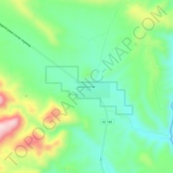
Navn: Topografisk kort Jakes Corner, højde, relief.
Sted: Jakes Corner, Gila County, Arizona, United States (33.99060 -111.33930 34.03060 -111.29930)
Gjennomsnittlig høyde: 916 m
Minste høyde: 788 m
Maksimal høyde: 1 179 m
Gi en donasjon
Andre topografiske kart
Klikk på et kart for å se dets topografi, dets høyde og dets relieff.
Pine
United States > Arizona > Gila County > Pine
Pine and the adjacent community of Strawberry are rapidly growing vacation and retirement centers in north-central Arizona, below the Mogollon Rim. Pine's elevation is 5,448 feet (1,661 m), and the Pine post office was established in 1884.
Gjennomsnittlig høyde: 1 794 m
Gi en donasjon
Star Valley
United States > Arizona > Gila County
According to the United States Census Bureau, the town has a total area of 36.1 square miles (93.6 km2), of which 0.01 square miles (0.02 km2), or 0.03%, is water. Star Valley sits at an elevation of 4,650 feet (1,420 m) and takes its name from the valley in which it is located, formed by Houston Creek, which…
Gjennomsnittlig høyde: 1 509 m
Gi en donasjon
Gi en donasjon