
Gi en donasjon
Topografisk kart Gougnies
Klikk på kartet for å vise høyde.
Gi en donasjon
Om dette kartet
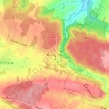
Navn: Topografisk kort Gougnies, højde, relief.
Sted: Gougnies, Gerpinnes, Charleroi, Hainaut, Wallonia, 6280, Belgium (50.33444 4.55716 50.37444 4.59716)
Gjennomsnittlig høyde: 208 m
Minste høyde: 138 m
Maksimal høyde: 249 m
Gi en donasjon
Andre topografiske kart
Klikk på et kart for å se dets topografi, dets høyde og dets relieff.
Charleroi
The topography of Charleroi is influenced by the valley of the river Sambre, which flows from west to east before joining the Meuse at Namur. The Piéton river flows from north to south to join the Sambre at Dampremy. The Charleroi-Brussels canal is dug in the valley of this stream. The Eau d'Heure river comes…
Gjennomsnittlig høyde: 152 m
Gi en donasjon
Charleroi
The topography of Charleroi is influenced by the valley of the river Sambre, which flows from west to east before joining the Meuse at Namur. The Piéton river flows from north to south to join the Sambre at Dampremy. The Charleroi-Brussels canal is dug in the valley of this stream. The Eau d'Heure river comes…
Gjennomsnittlig høyde: 152 m