
Takk for at du støtter denne siden ❤️
Gi en donasjon
Gi en donasjon
Topografisk kart Bass Island
Klikk på kartet for å vise høyde.
Takk for at du støtter denne siden ❤️
Gi en donasjon
Gi en donasjon
Om dette kartet
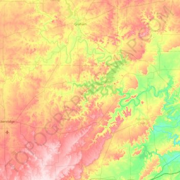
Navn: Topografisk kort Bass Island, højde, relief.
Sted: Bass Island, Palo Pinto County, Texas, United States (32.54623 -98.86089 33.18623 -98.22089)
Gjennomsnittlig høyde: 357 m
Minste høyde: 232 m
Maksimal høyde: 493 m
Takk for at du støtter denne siden ❤️
Gi en donasjon
Gi en donasjon
Andre topografiske kart
Klikk på et kart for å se dets topografi, dets høyde og dets relieff.
Mineral Wells Fossil Park
United States > Texas > Palo Pinto County > Mineral Wells
Gjennomsnittlig høyde: 283 m
Takk for at du støtter denne siden ❤️
Gi en donasjon
Gi en donasjon
Takk for at du støtter denne siden ❤️
Gi en donasjon
Gi en donasjon