
Takk for at du støtter denne siden ❤️
Gi en donasjon
Gi en donasjon
Topografisk kart Perryville
Klikk på kartet for å vise høyde.
Takk for at du støtter denne siden ❤️
Gi en donasjon
Gi en donasjon
Om dette kartet
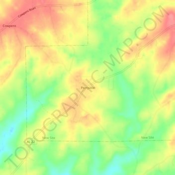
Navn: Topografisk kort Perryville, højde, relief.
Sted: Perryville, Tallapoosa County, Alabama, United States (33.00123 -85.82135 33.04123 -85.78135)
Gjennomsnittlig høyde: 230 m
Minste høyde: 188 m
Maksimal høyde: 265 m
Takk for at du støtter denne siden ❤️
Gi en donasjon
Gi en donasjon
Andre topografiske kart
Klikk på et kart for å se dets topografi, dets høyde og dets relieff.
Takk for at du støtter denne siden ❤️
Gi en donasjon
Gi en donasjon
Takk for at du støtter denne siden ❤️
Gi en donasjon
Gi en donasjon
Takk for at du støtter denne siden ❤️
Gi en donasjon
Gi en donasjon
Camp Hill
United States > Alabama > Tallapoosa County > Camp Hill > Camp Hill
Gjennomsnittlig høyde: 203 m