
Takk for at du støtter denne siden ❤️
Gi en donasjon
Gi en donasjon
Topografisk kart Newtonmore
Klikk på kartet for å vise høyde.
Takk for at du støtter denne siden ❤️
Gi en donasjon
Gi en donasjon
Newtonmore
Newtonmore is located within the Cairngorms National Park, approximately 3 miles (5 km) southwest of Kingussie and 15 miles (24 km) southwest of Aviemore. It is on the northeastern bank of the River Spey, between the River Calder and the Allt Lairaidh, at an altitude of approximately 250 metres (820 ft).
Takk for at du støtter denne siden ❤️
Gi en donasjon
Gi en donasjon
Om dette kartet
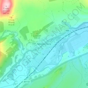
Navn: Topografisk kort Newtonmore, højde, relief.
Sted: Newtonmore, Highland, Scotland, PH20 1DN, United Kingdom (57.04553 -4.13936 57.08553 -4.09936)
Gjennomsnittlig høyde: 283 m
Minste høyde: 223 m
Maksimal høyde: 536 m
Takk for at du støtter denne siden ❤️
Gi en donasjon
Gi en donasjon
Andre topografiske kart
Klikk på et kart for å se dets topografi, dets høyde og dets relieff.