
Gi en donasjon
Topografisk kart Mount Zion
Klikk på kartet for å vise høyde.
Gi en donasjon
Om dette kartet
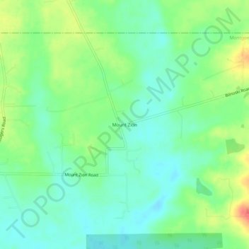
Navn: Topografisk kort Mount Zion, højde, relief.
Sted: Mount Zion, Montgomery County, Texas, 77358, United States (30.47409 -95.45216 30.51409 -95.41216)
Gjennomsnittlig høyde: 88 m
Minste høyde: 70 m
Maksimal høyde: 121 m
Gi en donasjon
Andre topografiske kart
Klikk på et kart for å se dets topografi, dets høyde og dets relieff.
Conroe
United States > Texas > Montgomery County
Conroe features a predominantly flat terrain with an average elevation of approximately 220 feet (67 meters) above sea level. The area is characterized by gently rolling hills interspersed with numerous lakes and wetlands, including the prominent Lake Conroe, which spans about 21,000 acres. The lake, formed by…
Gjennomsnittlig høyde: 62 m
The Woodlands
United States > Texas > Montgomery County
It is in a heavily forested area, and much of the community has retained trees for shade and decoration. The terrain is essentially flat, with the exception of topographic variations ranging from 125 to 175 feet between Spring Creek and Flintridge Drive.
Gjennomsnittlig høyde: 47 m
Gi en donasjon
Gi en donasjon
The Woodlands
United States > Texas > Montgomery County
The Woodlands is in a heavily forested area, and much of the community has retained trees for shade and decoration. The terrain is essentially flat, with the exception of topographic variations ranging from 125 to 175 feet above sea level between Spring Creek and Flintridge Drive.
Gjennomsnittlig høyde: 47 m
Gi en donasjon
Gi en donasjon
Gi en donasjon
Panorama Lake
United States > Texas > Montgomery County > Panorama Village
Gjennomsnittlig høyde: 94 m
Gi en donasjon
Gi en donasjon