
Gi en donasjon
Topografisk kart Davidsonville
Klikk på kartet for å vise høyde.
Gi en donasjon
Om dette kartet
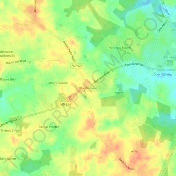
Navn: Topografisk kort Davidsonville, højde, relief.
Gjennomsnittlig høyde: 37 m
Minste høyde: 11 m
Maksimal høyde: 60 m
Gi en donasjon
Andre topografiske kart
Klikk på et kart for å se dets topografi, dets høyde og dets relieff.
Annapolis
United States > Maryland > Anne Arundel County
Annapolis lies within the humid subtropical climate zone (Köppen Cfa), with hot, humid summers, cool winters, and generous precipitation year-round. Low elevation and proximity to the Chesapeake Bay give the area more moderate spring and summertime temperatures and slightly less extreme winter lows than…
Gjennomsnittlig høyde: 8 m
Gi en donasjon
Pasadena
United States > Maryland > Anne Arundel County > Pasadena
Pasadena is located at 39°6′46″N 76°33′7″W / 39.11278°N 76.55194°W / 39.11278; -76.55194 (39.112809, −76.551871) in northern Anne Arundel County. It is bordered to the north by the city of Baltimore, to the east by the tidal Patapsco River and by Riviera Beach, to the southeast by Lake…
Gjennomsnittlig høyde: 13 m
Annapolis
United States > Maryland > Anne Arundel County
Annapolis lies within the humid subtropical climate zone (Köppen Cfa), with hot, humid summers, cool winters, and generous precipitation year-round. Low elevation and proximity to the Chesapeake Bay give the area more moderate spring and summertime temperatures and slightly less extreme winter lows than…
Gjennomsnittlig høyde: 8 m
Quiet Waters Park
United States > Maryland > Anne Arundel County > Annapolis > Georgetown East
Gjennomsnittlig høyde: 7 m
Gi en donasjon
Gi en donasjon
Annapolis Neck
United States > Maryland > Anne Arundel County > Highland Beach
Gjennomsnittlig høyde: 4 m
Gi en donasjon
Patapsco River
United States > Maryland > Anne Arundel County > Riviera Beach
The Patapsco River mainstem begins at the confluence of the North and South Branches, near Marriottsville, approximately 15 miles (24 km) west of downtown Baltimore. The 19.4-mile-long (31.2 km)[1] South Branch rises further west at Parr's Spring, where Howard County, Carroll, Frederick, and Montgomery…
Gjennomsnittlig høyde: 7 m
Gi en donasjon
Pasadena
United States > Maryland > Anne Arundel County > Pasadena
Pasadena is located at 39°6′46″N 76°33′7″W / 39.11278°N 76.55194°W / 39.11278; -76.55194 (39.112809, −76.551871) in northern Anne Arundel County. It is bordered to the north by the city of Baltimore, to the east by the tidal Patapsco River and by Riviera Beach, to the southeast by Lake…
Gjennomsnittlig høyde: 13 m
Naval Academy
United States > Maryland > Anne Arundel County > Naval Academy
Gjennomsnittlig høyde: 6 m
Gi en donasjon
Gi en donasjon
Gi en donasjon
Cape St. Claire
United States > Maryland > Anne Arundel County > Cape Saint Claire
Gjennomsnittlig høyde: 12 m
Annapolis
United States > Maryland > Anne Arundel County
Annapolis lies within the humid subtropical climate zone (Köppen Cfa), with hot, humid summers, cool winters, and generous precipitation year-round. Low elevation and proximity to the Chesapeake Bay give the area more moderate spring and summertime temperatures and slightly less extreme winter lows than…
Gjennomsnittlig høyde: 8 m
Maryland City
United States > Maryland > Anne Arundel County > Maryland City
Gjennomsnittlig høyde: 53 m
Gi en donasjon