
Gi en donasjon
Topografisk kart Damascus
Klikk på kartet for å vise høyde.
Gi en donasjon
Damascus
As an unincorporated area, Damascus' boundaries are not officially defined. Damascus is recognized by the United States Census Bureau as a census-designated place, and by the United States Geological Survey as a populated place located. Damascus proper is a locally high spot at 847 ft (258m) above sea level, while other portions of the area described as Damascus are as high as 866 ft (264m) above sea level. Due to a quirk in the layout of Montgomery County, the highest elevation in the county is actually within what is considered Mt. Airy, MD, measuring 883 ft (269m) above sea level at the Full Gospel Church. This peak just southwest of Mt. Airy is actually the highest elevation in the immediately adjacent Washington D.C. suburbs and is located inside an often overlooked strip of Montgomery County which is approximately 1 mile (1.6 km) long and of varying width, generally a few hundred feet (~100 M) wide. While the Full Gospel Church building is within Montgomery County, the driveways are in Frederick County and portions of the parking lot are in Howard County.
Gi en donasjon
Om dette kartet
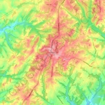
Navn: Topografisk kort Damascus, højde, relief.
Sted: Damascus, Montgomery County, Maryland, 20872, United States (39.24844 -77.24387 39.32844 -77.16387)
Gjennomsnittlig høyde: 204 m
Minste høyde: 140 m
Maksimal høyde: 260 m
Gi en donasjon
Andre topografiske kart
Klikk på et kart for å se dets topografi, dets høyde og dets relieff.
Gi en donasjon
Silver Spring
United States > Maryland > Montgomery County > Silver Spring
Gjennomsnittlig høyde: 86 m
Gi en donasjon
Cabin John
United States > Maryland > Montgomery County > Cabin John
Historically, Cabin John has been part of the region known as the Potomac Gorge (Potomac Palisades), an approximately 15-mile-long (24 km) corridor or "fall zone" that sees a transition between the hard bedrock of the Piedmont to the softer rocks and soils of the Atlantic Coastal Plain and representing a drop…
Gjennomsnittlig høyde: 48 m
Gi en donasjon
Ten Mile Creek
United States > Maryland > Montgomery County > Ten Mile Creek
Gjennomsnittlig høyde: 166 m
Gi en donasjon
Damascus
United States > Maryland > Montgomery County > Damascus
As an unincorporated area, Damascus' boundaries are not officially defined. Damascus is recognized by the United States Census Bureau as a census-designated place, and by the United States Geological Survey as a populated place located at 39°16′16″N 77°12′22″W / 39.27111°N 77.20611°W /…
Gjennomsnittlig høyde: 195 m
North Potomac
United States > Maryland > Montgomery County > North Potomac
Between the 1990 and 2000 census, North Potomac gained and lost land. The loss was caused when a portion of the North Potomac territory, plus Potomac territory, was used to create the Travilah census designated place. According to the United States Census Bureau, North Potomac has a total area of 6.6 square…
Gjennomsnittlig høyde: 116 m
Burnt Mills West Special Park
United States > Maryland > Montgomery County > Burnt Mills > Burnt Mills Manor
Gjennomsnittlig høyde: 100 m
Gi en donasjon
Damascus
United States > Maryland > Montgomery County > Damascus
As an unincorporated area, Damascus' boundaries are not officially defined. Damascus is recognized by the United States Census Bureau as a census-designated place, and by the United States Geological Survey as a populated place located. Damascus proper is a locally high spot at 847 ft (258m) above sea level,…
Gjennomsnittlig høyde: 195 m
Gi en donasjon
Gi en donasjon
Forest Glen
United States > Maryland > Montgomery County > Forest Glen > McKenney Hills
Gjennomsnittlig høyde: 105 m
Upper Long Branch Neighborhood Park
United States > Maryland > Montgomery County > Four Corners
Gjennomsnittlig høyde: 87 m
Gi en donasjon
Gi en donasjon
Silver Spring
United States > Maryland > Montgomery County > Silver Spring
Gjennomsnittlig høyde: 86 m
Gi en donasjon
Damascus
United States > Maryland > Montgomery County > Damascus
As an unincorporated area, Damascus' boundaries are not officially defined. Damascus is recognized by the United States Census Bureau as a census-designated place, and by the United States Geological Survey as a populated place located. Damascus proper is a locally high spot at 847 ft (258m) above sea level,…
Gjennomsnittlig høyde: 195 m
Gi en donasjon
Silver Spring
United States > Maryland > Montgomery County > Silver Spring
Gjennomsnittlig høyde: 86 m
Colt Terrace Neighborhood Park
United States > Maryland > Montgomery County > Silver Spring
Gjennomsnittlig høyde: 119 m
Gi en donasjon
Forest Glen
United States > Maryland > Montgomery County > Forest Glen > McKenney Hills
Gjennomsnittlig høyde: 105 m
Gi en donasjon
Travilah
United States > Maryland > Montgomery County > Travilah
The United States Geological Survey lists six features in Montgomery County with Travilah in all or part of their name. The Travilah Census Designated Place has an ID of 2390400 and an elevation of 233 feet. It has a latitude of 390325N and a longitude of 0771445W—a location of 39°3′25″N…
Gjennomsnittlig høyde: 96 m
Gi en donasjon
Silver Spring
United States > Maryland > Montgomery County > Silver Spring
Gjennomsnittlig høyde: 86 m
North Kensington
United States > Maryland > Montgomery County > North Kensington
Gjennomsnittlig høyde: 103 m
Gi en donasjon
Forest Glen
United States > Maryland > Montgomery County > Forest Glen > Forest Estates
Gjennomsnittlig høyde: 105 m
Gi en donasjon
North Bethesda
United States > Maryland > Montgomery County > North Bethesda
Gjennomsnittlig høyde: 98 m