
Gi en donasjon
Topografisk kart Cherokee Ridge
Klikk på kartet for å vise høyde.
Gi en donasjon
Om dette kartet
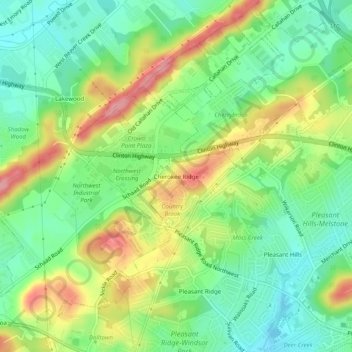
Navn: Topografisk kort Cherokee Ridge, højde, relief.
Gjennomsnittlig høyde: 336 m
Minste høyde: 289 m
Maksimal høyde: 409 m
Gi en donasjon
Andre topografiske kart
Klikk på et kart for å se dets topografi, dets høyde og dets relieff.
Knoxville
United States > Tennessee > Knox County
According to the United States Census Bureau, the city has a total area of 104.2 square miles (269.8 km2), of which 98.5 square miles (255.2 km2) is land and 5.6 square miles (14.6 km2), or 5.42%, is water. Elevations range from just over 800 feet (240 m) along the riverfront to just over 1,000 feet (300 m) on…
Gjennomsnittlig høyde: 307 m
Knoxville
United States > Tennessee > Knox County
Knoxville features a diverse topography characterized by its position in the Great Appalachian Valley. The city sits at an elevation of approximately 886 feet above sea level, nestled between the Great Smoky Mountains to the east and the Cumberland Plateau to the west. This geographical setup results in a…
Gjennomsnittlig høyde: 307 m
University of Tennessee
United States > Tennessee > Knox County > Knoxville
Gjennomsnittlig høyde: 272 m
Fort Dickerson Quarry
United States > Tennessee > Knox County > Knoxville
Gjennomsnittlig høyde: 277 m
Gi en donasjon
Halls Crossroads
United States > Tennessee > Knox County
It is located at 36°04′49″N 83°56′33″W / 36.08028°N 83.94250°W / 36.08028; -83.94250. It has an elevation of 1,040 feet.
Gjennomsnittlig høyde: 346 m
Gi en donasjon
Victor Ashe Park
United States > Tennessee > Knox County > Knoxville > Windsor Park
Gjennomsnittlig høyde: 314 m
Knoxville
United States > Tennessee > Knox County
According to the United States Census Bureau, the city has a total area of 104.2 square miles (269.8 km2), of which 98.5 square miles (255.2 km2) is land and 5.6 square miles (14.6 km2), or 5.42%, is water. Elevations range from just over 800 feet (240 m) along the riverfront to just over 1,000 feet (300 m) on…
Gjennomsnittlig høyde: 307 m
House Mountain
United States > Tennessee > Knox County
House Mountain is a mountain located in Corryton, Tennessee, United States, about 8 miles (13 km) northeast of Knoxville. Rising to an elevation of 2,064 feet (629 m) above sea level, House Mountain is the highest point in Knox County.
Gjennomsnittlig høyde: 394 m
Knoxville
United States > Tennessee > Knox County
According to the United States Census Bureau, the city has a total area of 104.2 square miles (269.8 km2), of which 98.5 square miles (255.2 km2) is land and 5.6 square miles (14.6 km2), or 5.42%, is water. Elevations range from just over 800 feet (240 m) along the riverfront to just over 1,000 feet (300 m) on…
Gjennomsnittlig høyde: 307 m
Gi en donasjon
Halls Crossroads
United States > Tennessee > Knox County
It is located at 36°04′49″N 83°56′33″W / 36.08028°N 83.94250°W / 36.08028; -83.94250. It has an elevation of 1,040 feet.
Gjennomsnittlig høyde: 346 m
Knoxville
United States > Tennessee > Knox County
According to the United States Census Bureau, the city has a total area of 104.2 square miles (269.8 km2), of which 98.5 square miles (255.2 km2) is land and 5.6 square miles (14.6 km2), or 5.42%, is water. Elevations range from just over 800 feet (240 m) along the riverfront to just over 1,000 feet (300 m) on…
Gjennomsnittlig høyde: 307 m
Gi en donasjon