
Gi en donasjon
Topografisk kart Norfleet
Klikk på kartet for å vise høyde.
Gi en donasjon
Om dette kartet
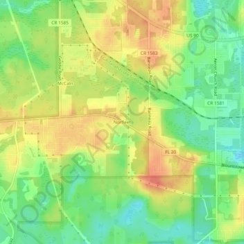
Navn: Topografisk kort Norfleet, højde, relief.
Sted: Norfleet, Leon County, Florida, 32310, United States (30.42270 -84.41185 30.46270 -84.37185)
Gjennomsnittlig høyde: 37 m
Minste høyde: 12 m
Maksimal høyde: 60 m
Gi en donasjon
Andre topografiske kart
Klikk på et kart for å se dets topografi, dets høyde og dets relieff.
Tallahassee
United States > Florida > Leon County
Tallahassee features a distinctive topography that is characterized by hilly terrain, which is somewhat atypical for the generally flat landscape of the state. The city is located at the southern end of the Red Hills Region and just above the Cody Scarp, with elevations ranging from about 7 feet near its low…
Gjennomsnittlig høyde: 36 m
Lake Jackson
United States > Florida > Leon County
The lake is located in the Red Hills Region, and has fluctuated from periods of being dry to a maximum elevation of 96 feet (29 m) above sea level. The lake is approximately 7.5 miles (12 km) long and its area is 6.2 square miles (16 km2). There is no outflow from streams or runoff.
Gjennomsnittlig høyde: 45 m
Lake Ella
United States > Florida > Leon County > Tallahassee
In 1986, Lake Ella underwent extensive rehabilitation including sediment removal, reshaping of the shoreline, reducing the number of stormwater inflow pipes, and installation of an automatic alum treatment system. Lake Ella receives stormwater runoff from an urban watershed that is approximately 157 acres…
Gjennomsnittlig høyde: 56 m
Fred O. Drake Park at Lake Ella
United States > Florida > Leon County > Tallahassee
Gjennomsnittlig høyde: 56 m
Gi en donasjon
Tallahassee
United States > Florida > Leon County
Tallahassee's terrain is hilly by Florida standards, being at the southern end of the Red Hills Region, just above the Cody Scarp. The elevation varies from near sea level to just over 200 feet (61 m), with the state capitol on one of the highest hills in the city. The city includes two large lake basins, Lake…
Gjennomsnittlig høyde: 36 m
Tom Brown Park
United States > Florida > Leon County > Tallahassee > Perkins
Gjennomsnittlig høyde: 32 m
Tallahassee
United States > Florida > Leon County
Tallahassee's terrain is hilly by Florida standards, being at the southern end of the Red Hills Region, just above the Cody Scarp. The elevation varies from near sea level to just over 200 feet (61 m), with the state capitol on one of the highest hills in the city. The city includes two large lake basins, Lake…
Gjennomsnittlig høyde: 36 m
Gi en donasjon
Tallahassee
United States > Florida > Leon County
Tallahassee's terrain is hilly by Florida standards, being at the southern end of the Red Hills Region, just above the Cody Scarp. The elevation varies from near sea level to just over 200 feet (61 m), with the state capitol on one of the highest hills in the city. The city includes two large lake basins, Lake…
Gjennomsnittlig høyde: 36 m
Gi en donasjon