
Gi en donasjon
Topografisk kart Ida
Klikk på kartet for å vise høyde.
Gi en donasjon
Om dette kartet
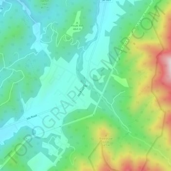
Navn: Topografisk kort Ida, højde, relief.
Sted: Ida, Page County, Virginia, United States (38.56901 -78.44390 38.60901 -78.40390)
Gjennomsnittlig høyde: 462 m
Minste høyde: 307 m
Maksimal høyde: 867 m
Gi en donasjon
Andre topografiske kart
Klikk på et kart for å se dets topografi, dets høyde og dets relieff.
Shenandoah National Park
United States > Virginia > Page County
Shenandoah National Park lies along the Blue Ridge Mountains in north-central Virginia. These mountains form a distinct highland rising to elevations above 4,000 feet (1,200 m). Local topographic relief between the Blue Ridge Mountains and Shenandoah Valley exceeds 3,000 feet (910 m) at some locations. The…
Gjennomsnittlig høyde: 335 m
Gi en donasjon
Shenandoah National Park
United States > Virginia > Page County
Shenandoah National Park lies along the Blue Ridge Mountains in north-central Virginia. These mountains form a distinct highland rising to elevations above 4,000 feet (1,200 m). Local topographic relief between the Blue Ridge Mountains and Shenandoah Valley exceeds 3,000 feet (900 m) at some locations. The…
Gjennomsnittlig høyde: 335 m
Gi en donasjon