
Gi en donasjon
Topografisk kart Datil
Klikk på kartet for å vise høyde.
Gi en donasjon
Om dette kartet
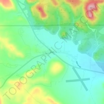
Navn: Topografisk kort Datil, højde, relief.
Sted: Datil, Catron County, New Mexico, United States (34.12503 -107.86336 34.16503 -107.82336)
Gjennomsnittlig høyde: 2 279 m
Minste høyde: 2 221 m
Maksimal høyde: 2 398 m
Gi en donasjon
Andre topografiske kart
Klikk på et kart for å se dets topografi, dets høyde og dets relieff.
Reserve
United States > New Mexico > Catron County
Reserve has a Mediterranean climate of the warm-summer type (Köppen: Csb), unusual in New Mexico. Despite having mild to hot daytime highs year round, temperatures substantially cool off during nighttime due to Reserve's high elevation and aridity. Even in the summertime, 90 degree days can cool off into the…
Gjennomsnittlig høyde: 1 780 m
Gila Wilderness
United States > New Mexico > Catron County
The Gila Wilderness is located in southwest New Mexico, north of Silver City and east of Reserve. It contains the West Fork, Middle Fork and much of the East Fork of the Gila River; riverside elevations of around 4,850 feet (1,480 m) are the lowest in the wilderness. The Mogollon Mountains traverse an arc…
Gjennomsnittlig høyde: 2 085 m