
Gi en donasjon
Topografisk kart Yalova
Klikk på kartet for å vise høyde.
Gi en donasjon
Om dette kartet
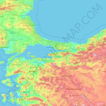
Navn: Topografisk kort Yalova, højde, relief.
Sted: Yalova, Marmara Region, Turkey (37.97954 26.56870 43.17954 31.76870)
Gjennomsnittlig høyde: 404 m
Minste høyde: -2 m
Maksimal høyde: 2 703 m
Gi en donasjon
Andre topografiske kart
Klikk på et kart for å se dets topografi, dets høyde og dets relieff.
Gi en donasjon
Antakya
Antakya's climate is classified as hot-summer Mediterranean (Köppen: Csa) or dry-summer humid subtropical (Trewartha: Cf or wet Cs). The city experiences hot, dry summers, and mild, wet winters; though its higher altitude allows for lower temperatures than the coast.
Gjennomsnittlig høyde: 385 m
Kaş
As the tenth largest district of Antalya as of 2021, Kaş is on a hill running down to the Turquoise Coast of southwestern Turkey. The district has a typical Mediterranean climate of hot, dry summers and mild, wet winters, which allows the growth of oranges, lemons and bananas. The lowland areas are also…
Gjennomsnittlig høyde: 837 m
Gi en donasjon
Taurus Mountains
The mountains have a Mediterranean climate, with dry summers and rainy winters. Temperatures vary with elevation, with warm winters on the lower coastal slopes and cold winters in the high mountains and in the interior.
Gjennomsnittlig høyde: 828 m
Gi en donasjon
Anatolia
Anatolia (Turkish: Anadolu), also known as Asia Minor, is a peninsula in West Asia that makes up the majority of the land area of Turkey. It is the westernmost protrusion of Asia and is geographically bounded by the Mediterranean Sea to the south, the Aegean Sea to the west, the Turkish Straits to the…
Gjennomsnittlig høyde: 518 m
Antalya
The highest point of the Taurus mountains is Akdağ at an altitude of 3025 metres. Located to the northwest of the city centre and at a distance of 50 km (31 mi) is the Saklıkent ski and recreation centre on Beydağları. Here one can ski and then go down to the shore and into the sea during the months of…
Gjennomsnittlig høyde: 644 m
Gi en donasjon
Gi en donasjon
Gi en donasjon
Prince Islands
All islands contain hills, the highest being Büyükada's Aya Yorgi Hill with 203 meters of elevation.
Gjennomsnittlig høyde: 12 m
Gi en donasjon
Gi en donasjon
Bağcılar
Bağcılar is located on the European side of Istanbul, within the service boundaries of Istanbul Metropolitan Municipality. Its area is 22 km2 (8.5 sq mi). The district is now known as an immigrant quarter. It lies between E-5 and TEM. In the south Bahçelievler, in the west Küçükçekmece, in the northwest…
Gjennomsnittlig høyde: 85 m
Gi en donasjon
Gi en donasjon
Gi en donasjon
Gi en donasjon
Gi en donasjon
Şereflikoçhisar
Şereflikoçhisar, formerly known as Koçhisar, is a municipality and district of Ankara Province, Turkey. Its area is 2,155 km2, and its population is 33,140 (2022). It is 148 km south of the city of Ankara. Its average elevation ranges between 900 and 1,200 m, with the highest point being Mt. Karasenir at…
Gjennomsnittlig høyde: 1 009 m
Gi en donasjon
Gi en donasjon
Anatolia
Anatolia (Turkish: Anadolu), also known as Asia Minor, is a peninsula in West Asia that makes up the majority of the land area of Turkey. It is the westernmost protrusion of Asia and is geographically bounded by the Mediterranean Sea to the south, the Aegean Sea to the west, the Turkish Straits to the…
Gjennomsnittlig høyde: 518 m
Gi en donasjon
Erdemli
Erdemli is a quiet rural district where the people are conservative, and is traditionally a stronghold of Turkish nationalist politicians; however some departments of Mersin University are opening branches here which will surely have an effect on the cultural and social life of Erdemli in the future. There is…
Gjennomsnittlig høyde: 966 m
Gi en donasjon
Zeytinburnu
Zeytinburnu is located on the part of Çatalca peninsula that is apart from historical peninsula with Walls of Constantinople and overlooks to the Marmara Sea in İstanbul. Its altitude generally increases from south to north, and in south districts (Sümer, Nuripaşa, Kazlıçeşme etc.) embankments, alluvium…
Gjennomsnittlig høyde: 37 m
Gi en donasjon
Gi en donasjon
Bergama
Kozak Plateau (Kozak Yaylası) is a high plain at an altitude varying between 500 and 1,000 metres (1,600 and 3,300 feet) and starting at a distance of 20 km (12 mi) from Bergama center in the northern direction. The plain is a favorite regional excursion area, famed for its hand-made textile products and pine…
Gjennomsnittlig høyde: 323 m
Gi en donasjon
Gi en donasjon
Lake Van
Lake Van (Turkish: Van Gölü; Armenian: Վանա լիճ, romanized: Vana lič̣; Kurdish: Gola Wanê) is the largest lake in Turkey. It lies in the Eastern Anatolia Region of Turkey in the provinces of Van and Bitlis, in the Armenian highlands. It is a saline soda lake, receiving water from many small streams…
Gjennomsnittlig høyde: 1 902 m
Batman
The province occupies an area of 4,477 km2 (1,729 sq mi). It lies in a mountainous area with the average elevation of 550 meters which contains several thousands of caves. The tallest mountains are Sason Dağları (2500 m), Meleto (2967 m), Kuşaklı Dağı (1947 m), Avcı Dağı (2121 m), Meydanok Tepesi…
Gjennomsnittlig høyde: 941 m
Bakırköy
While the average elevation is 20-30 meters throughout Bakırköy, this value rises to 70 meters in the north of the district. The ridges slope north-south towards the Marmara Sea. The coastal length of Bakırköy is 13 km, with small cliffs in Yeşilköy and Yeşilyurt neighborhoods and a sandy beach in Florya.
Gjennomsnittlig høyde: 21 m
Gi en donasjon
Gi en donasjon
Gi en donasjon
Batman
The province occupies an area of 4,477 km2 (1,729 sq mi). It lies in a mountainous area with the average elevation of 550 meters which contains several thousands of caves. The tallest mountains are Sason Dağları (2500 m), Meleto (2967 m), Kuşaklı Dağı (1947 m), Avcı Dağı (2121 m), Meydanok Tepesi…
Gjennomsnittlig høyde: 941 m
Çubuk
Çubuk is a municipality and district of Ankara Province, Turkey. Its area is 1,198 km2, and its population is 95,449 (2022). Çubuk is in a flat plain 35 km north of the city of Ankara, where Ankara airport is located. Its elevation is 1,000 m (3,281 ft).
Gjennomsnittlig høyde: 1 267 m
Gi en donasjon