
Gi en donasjon
Topografisk kart Pilot Knob
Klikk på kartet for å vise høyde.
Gi en donasjon
Om dette kartet
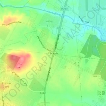
Navn: Topografisk kort Pilot Knob, højde, relief.
Sted: Pilot Knob, Travis County, Texas, 78719, United States (30.14417 -97.71322 30.18417 -97.67322)
Gjennomsnittlig høyde: 166 m
Minste høyde: 134 m
Maksimal høyde: 213 m
Gi en donasjon
Andre topografiske kart
Klikk på et kart for å se dets topografi, dets høyde og dets relieff.
Austin
United States > Texas > Travis County
Austin features a diverse and varied topography shaped by its position along the Balcones Fault. The city’s elevation ranges from about 425 feet to approximately 1,000 feet above sea level, creating a landscape characterized by rolling hills and elevated areas particularly in the western regions. To the…
Gjennomsnittlig høyde: 216 m
Lago Vista
United States > Texas > Travis County
Lago Vista is situated on the northern shore of Lake Travis within the Texas Hill Country. The area's terrain is notably rugged, with steep limestone hills and canyons. Elevations range from about 774 feet near the lake to 1,220 feet near Rusty Allen Airport, making it one of the highest points in Travis…
Gjennomsnittlig høyde: 251 m
Austin
United States > Texas > Travis County
The elevation of Austin varies from 425 feet (130 m) to approximately 1,000 feet (305 m) above sea level. Due to the fact it straddles the Balcones Fault, much of the eastern part of the city is flat, with heavy clay and loam soils, whereas the western part and western suburbs consist of rolling hills on the…
Gjennomsnittlig høyde: 216 m
Gi en donasjon
Shoal Beach at Town Lake Metropolitan Park
United States > Texas > Travis County > Austin
Gjennomsnittlig høyde: 152 m
Gi en donasjon
Bee Cave
United States > Texas > Travis County
According to the United States Census Bureau in 2010, the city has a total area of 2.6 square miles (6.7 km2), all of it land. Prior to the 2010 census, Bee Cave went from being a village to being a city, increasing its area to 6.8 square miles (18 km2), all land. It borders Lakeway to the northwest. The…
Gjennomsnittlig høyde: 270 m
Circle C Ranch Metropolitan Park on Slaughter Creek
United States > Texas > Travis County > Austin
Gjennomsnittlig høyde: 259 m
Roy G. Guerrero Colorado River Metro Park
United States > Texas > Travis County > Austin
Gjennomsnittlig høyde: 141 m
Gi en donasjon
Walter E. Long Metropolitan Park
United States > Texas > Travis County > Austin
Gjennomsnittlig høyde: 174 m
Gi en donasjon
Austin
United States > Texas > Travis County
The elevation of Austin varies from 425 feet (130 m) to approximately 1,000 feet (305 m) above sea level. Due to the fact it straddles the Balcones Fault, much of the eastern part of the city is flat, with heavy clay and loam soils, whereas the western part and western suburbs consist of rolling hills on the…
Gjennomsnittlig høyde: 216 m
East Boggy Creek Greenbelt
United States > Texas > Travis County > Austin
Gjennomsnittlig høyde: 144 m
Austin
United States > Texas > Travis County
The elevation of Austin varies from 425 feet (130 m) to approximately 1,000 feet (305 m) above sea level. Due to the fact it straddles the Balcones Fault, much of the eastern part of the city is flat, with heavy clay and loam soils, whereas the western part and western suburbs consist of rolling hills on the…
Gjennomsnittlig høyde: 216 m
Gi en donasjon
Austin
United States > Texas > Travis County
The elevation of Austin varies from 425 feet (130 m) to approximately 1,000 feet (305 m) above sea level. Due to the fact it straddles the Balcones Fault, much of the eastern part of the city is flat, with heavy clay and loam soils, whereas the western part and western suburbs consist of rolling hills on the…
Gjennomsnittlig høyde: 216 m
Gi en donasjon
Gi en donasjon
Austin
United States > Texas > Travis County
The elevation of Austin varies from 425 feet (130 m) to approximately 1,000 feet (305 m) above sea level. Due to the fact it straddles the Balcones Fault, much of the eastern part of the city is flat, with heavy clay and loam soils, whereas the western part and western suburbs consist of rolling hills on the…
Gjennomsnittlig høyde: 216 m
Gi en donasjon
Austin
United States > Texas > Travis County
The elevation of Austin varies from 425 feet (130 m) to approximately 1,000 feet (305 m) above sea level. Due to the fact it straddles the Balcones Fault, much of the eastern part of the city is flat, with heavy clay and loam soils, whereas the western part and western suburbs consist of rolling hills on the…
Gjennomsnittlig høyde: 216 m
Gi en donasjon
Austin
United States > Texas > Travis County
The elevation of Austin varies from 425 feet (130 m) to approximately 1,000 feet (305 m) above sea level. Due to the fact it straddles the Balcones Fault, much of the eastern part of the city is flat, with heavy clay and loam soils, whereas the western part and western suburbs consist of rolling hills on the…
Gjennomsnittlig høyde: 216 m
Gi en donasjon
Bee Cave
United States > Texas > Travis County
According to the United States Census Bureau in 2010, the city has a total area of 2.6 square miles (6.7 km2), all of it land. Prior to the 2010 census, Bee Cave went from being a village to being a city, increasing its area to 6.8 square miles (18 km2), all land. It borders Lakeway to the northwest. The…
Gjennomsnittlig høyde: 270 m
Lago Vista
United States > Texas > Travis County
According to the United States Census Bureau, the city has a total area of 15.52 sq mi (40.2 km2) of which 14.6 sq mi (38 km2) is land and 0.6 sq mi (1.6 km2) (3.95%) is water. The peninsular city sits adjacent to, and partially within, the Balcones Canyonlands. Lago Vista has rugged terrain with elevations…
Gjennomsnittlig høyde: 251 m
Gi en donasjon