
Gi en donasjon
Topografisk kart Cullasaja
Klikk på kartet for å vise høyde.
Gi en donasjon
Om dette kartet
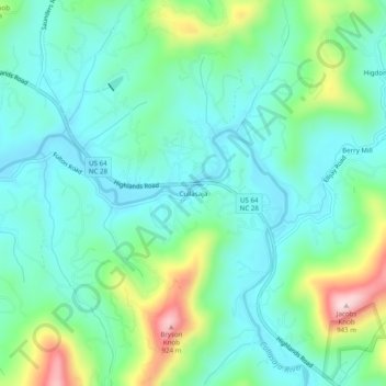
Navn: Topografisk kort Cullasaja, højde, relief.
Sted: Cullasaja, Macon County, North Carolina, United States (35.14510 -83.34376 35.18510 -83.30376)
Gjennomsnittlig høyde: 694 m
Minste høyde: 614 m
Maksimal høyde: 930 m
Gi en donasjon
Andre topografiske kart
Klikk på et kart for å se dets topografi, dets høyde og dets relieff.
Franklin
United States > North Carolina > Macon County
Franklin is characterized by its mountainous terrain, lying within the picturesque Appalachian Mountains. The area features rugged landscapes with elevations typically ranging from around 2,000 to 4,000 feet, creating dramatic vistas and deep valleys. The Little Tennessee River winds through the region, adding…
Gjennomsnittlig høyde: 675 m
Highlands
United States > North Carolina > Macon County
Highlands was founded in 1875 after its two founders, Samuel Truman Kelsey and Clinton Carter Hutchinson, drew lines from Chicago to Savannah and from New Orleans to New York City. They felt that the place where these lines met would eventually become a great trading center and commercial crossroads. Highlands…
Gjennomsnittlig høyde: 1 116 m
Gi en donasjon
Highlands
United States > North Carolina > Macon County
Highlands was founded in 1875 after its two founders, Samuel Truman Kelsey and Clinton Carter Hutchinson, drew lines from Chicago to Savannah and from New Orleans to New York City. They felt that the place where these lines met would eventually become a great trading center and commercial crossroads. Highlands…
Gjennomsnittlig høyde: 1 116 m
Franklin
United States > North Carolina > Macon County
The height of the falls is given as 200 ft (61 m) in Kevin Adams' book, North Carolina Waterfalls and 250 ft (77.1 m) by NCWaterfalls.com. However, Google Earth gives a height (based on the elevation of the water at the top of the falls and the elevation of the plunge pool at the bottom of the falls) of 137 ft…
Gjennomsnittlig høyde: 675 m