
Gi en donasjon
Topografisk kart Badme
Klikk på kartet for å vise høyde.
Gi en donasjon
Om dette kartet
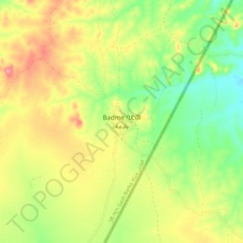
Navn: Topografisk kort Badme, højde, relief.
Sted: Badme, Eritrea (14.68608 37.76460 14.76608 37.84460)
Gjennomsnittlig høyde: 1 060 m
Minste høyde: 1 007 m
Maksimal høyde: 1 121 m
Gi en donasjon
Andre topografiske kart
Klikk på et kart for å se dets topografi, dets høyde og dets relieff.
Debub Region
Zoba Debub is one of the six Zobas (Regions) of Eritrea which is located in the southern part of the country with longitude of 38° 15' - 39° 40' East and latitude 14° 25' - 15° 15 North. It shares borders with Zoba Maekel (Central Region) in the north, Zoba Northern Red Sea in the east, Gash Barka in the…
Gjennomsnittlig høyde: 1 627 m
Gi en donasjon
Gash-Barka
It is situated in the south-west of the country, bordering the Anseba region to the north, and the Maekel (Central) and Debub (Southern) regions to the east; the country of Sudan lies to the west and Ethiopia to the south. The major crops in the region are bananas, tomatoes, cotton, onions, millet, sesame,…
Gjennomsnittlig høyde: 915 m
Gi en donasjon
Anseba
Anseba region (Tigrinya: ዞባ ዓንሰባ, Arabic: إقليم عنسبا) is an administrative region of Eritrea, located in northern Eritrea. The capital and the most populous city in the region is Keren. The region is named after Anseba River, which passed through most parts of the region. The average…
Gjennomsnittlig høyde: 749 m
Maekel Region
Central is the smallest region in Eritrea, and contains the major city and national capital, Asmara. Maekel is situated inland, and borders Anseba to the north-west, the Northern Red Sea region to the north-east, the Debub (Southern) region to the south, and Gash-Barka to the west. Much of the architecture in…
Gjennomsnittlig høyde: 1 902 m
Gi en donasjon
Debub Region
Zoba Debub is one of the six Zobas (Regions) of Eritrea which is located in the southern part of the country with longitude of 38° 15' - 39° 40' East and latitude 14° 25' - 15° 15 North. It shares borders with Zoba Maekel (Central Region) in the north, Zoba Northern Red Sea in the east, Gash Barka in the…
Gjennomsnittlig høyde: 1 627 m
Gi en donasjon
Northern Red Sea Region
The Northern Red Sea Region borders the Anseba, Maekel (Central) and Debub (Southern) regions to the west, and the Southern Red Sea Region to the east. It has an area of around 27,800 km2. The lowest point in Eritrea, Lake Kulul, is in this region. The topography of the region has coastal plains, which are…
Gjennomsnittlig høyde: 534 m
Anseba
Anseba Region (Tigrinya: ዞባ ዓንሰባ, Italian: Regione dell'Anseba) is an administrative region of Eritrea, located in northern Eritrea. The capital and the most populous city in the region is Keren. The region is named after Anseba River, which passed through most parts of the region. The average…
Gjennomsnittlig høyde: 749 m