
Gi en donasjon
Topografisk kart Deep Bottom Cove
Klikk på kartet for å vise høyde.
Gi en donasjon
Om dette kartet
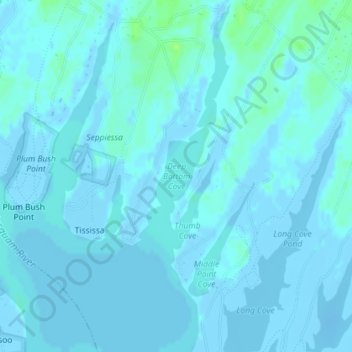
Navn: Topografisk kort Deep Bottom Cove, højde, relief.
Gjennomsnittlig høyde: 1 m
Minste høyde: -14 m
Maksimal høyde: 11 m
Gi en donasjon
Andre topografiske kart
Klikk på et kart for å se dets topografi, dets høyde og dets relieff.
Martha's Vineyard
United States > Massachusetts > Dukes County > West Tisbury
Martha's Vineyard features a diverse topography characterized by gently rolling hills, sandy beaches, and rugged coastline. The island spans approximately 100 square miles and boasts elevations that reach up to 289 feet at its highest point, offering panoramic views of the surrounding Atlantic Ocean. The…
Gjennomsnittlig høyde: 3 m
Martha's Vineyard
United States > Massachusetts > Dukes County > West Tisbury
Gjennomsnittlig høyde: 3 m
Martha's Vineyard
United States > Massachusetts > Dukes County > West Tisbury
Gjennomsnittlig høyde: 3 m
Martha's Vineyard
United States > Massachusetts > Dukes County > West Tisbury
Gjennomsnittlig høyde: 3 m
Gi en donasjon