
Takk for at du støtter denne siden ❤️
Gi en donasjon
Gi en donasjon
Topografisk kart Jajuara
Klikk på kartet for å vise høyde.
Takk for at du støtter denne siden ❤️
Gi en donasjon
Gi en donasjon
Jajuara
The climate is mainly dry and cool. In summer the temperature varies from 35 °C (95 °F) to 45 °C (113 °F). In winter it is typically 5 °C (41 °F) to 15 °C (59 °F). The elevation is 51m close to sea level. The soil is suited for agriculture, which is the main economic activity of the region.
Takk for at du støtter denne siden ❤️
Gi en donasjon
Gi en donasjon
Om dette kartet
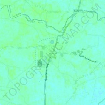
Navn: Topografisk kort Jajuara, højde, relief.
Sted: Jajuara, Katra, Muzaffarpur, Bihar, 843318, India (26.28463 85.64877 26.32463 85.68877)
Gjennomsnittlig høyde: 53 m
Minste høyde: 49 m
Maksimal høyde: 58 m
Takk for at du støtter denne siden ❤️
Gi en donasjon
Gi en donasjon