
Gi en donasjon
Topografisk kart Swinton
Klikk på kartet for å vise høyde.
Gi en donasjon
Swinton
Swinton lies at 53°30′44″N 2°20′28″W / 53.51222°N 2.34111°W / 53.51222; -2.34111 (53.5122°, -2.3412°), 167 miles (269 km) northwest of central London, and 4.2 miles (6.8 km) west-northwest of Manchester city centre. Topographically, Swinton occupies an area of gently sloping ground, roughly 213 feet (65 m) above sea level, and is on the south side of the River Irwell. Swinton lies in the west-central part of the Greater Manchester Urban Area, the UK's second largest conurbation. The M60 motorway passes Swinton on its northwest side.
Gi en donasjon
Om dette kartet
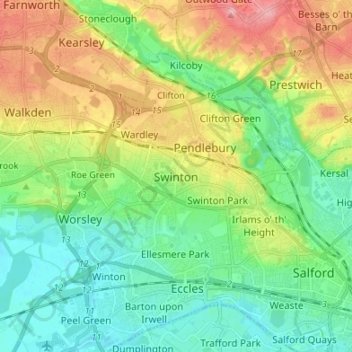
Navn: Topografisk kort Swinton, højde, relief.
Gjennomsnittlig høyde: 59 m
Minste høyde: 16 m
Maksimal høyde: 138 m
Gi en donasjon
Andre topografiske kart
Klikk på et kart for å se dets topografi, dets høyde og dets relieff.
Botany Bay Wood
United Kingdom > England > Salford > Worsley > Barton Moss
Gjennomsnittlig høyde: 23 m
Gi en donasjon