
Gi en donasjon
Topografisk kart Seneca Castle
Klikk på kartet for å vise høyde.
Gi en donasjon
Om dette kartet
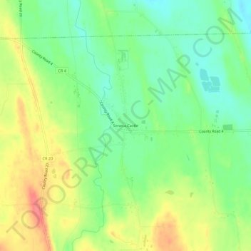
Navn: Topografisk kort Seneca Castle, højde, relief.
Gjennomsnittlig høyde: 244 m
Minste høyde: 216 m
Maksimal høyde: 279 m
Gi en donasjon
Andre topografiske kart
Klikk på et kart for å se dets topografi, dets høyde og dets relieff.
Town of Farmington
United States > New York > Ontario County
The land, at an average elevation of 600 feet above sea level, is compressed by the Wisconsin glaciation and slopes from an elevation of 700 feet at the southern border with the town of Canandaigua, to 500 feet at the north boundary with the town of Macedon. The land comprises drumlins and eskers. Other than…
Gjennomsnittlig høyde: 185 m
Gi en donasjon
Honeoye
United States > New York > Ontario County > Town of Richmond
Honeoye is located at 42°47′24″N 077°31′01″W / 42.79000°N 77.51694°W / 42.79000; -77.51694 (42.7900646, -77.5169374) and its elevation is 814 feet (248 m).
Gjennomsnittlig høyde: 268 m
Gi en donasjon
Gi en donasjon
Gi en donasjon
Town of Farmington
United States > New York > Ontario County
The land, at an average elevation of 600 feet above sea level, is compressed by the Wisconsin glaciation and slopes from an elevation of 700 feet at the southern border with the town of Canandaigua, to 500 feet at the north boundary with the town of Macedon. The land comprises drumlins and eskers. Other than…
Gjennomsnittlig høyde: 185 m
Gi en donasjon