
Gi en donasjon
Topografisk kart Tom London Dam
Klikk på kartet for å vise høyde.
Gi en donasjon
Om dette kartet
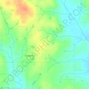
Navn: Topografisk kort Tom London Dam, højde, relief.
Sted: Tom London Dam, Cleveland County, Oklahoma, United States (34.97669 -97.22369 34.97679 -97.22359)
Gjennomsnittlig høyde: 324 m
Minste høyde: 307 m
Maksimal høyde: 351 m
Gi en donasjon
Andre topografiske kart
Klikk på et kart for å se dets topografi, dets høyde og dets relieff.
Norman
United States > Oklahoma > Cleveland County
Norman and the surrounding areas are mostly flat with an elevation near 1,171 feet (357 m). The terrain in the western section of Norman is prairie, while the eastern section, including the area surrounding Lake Thunderbird, consists of some 6,000 acres (24 km2) of lakes and Cross Timbers forest. The lowest…
Gjennomsnittlig høyde: 358 m
Lake Thunderbird
United States > Oklahoma > Cleveland County > Norman > Little Axe
Gjennomsnittlig høyde: 334 m
Gi en donasjon
Norman
United States > Oklahoma > Cleveland County
Norman and the surrounding areas are mostly flat with an elevation near 1,171 ft (357 m). The terrain in the western section of Norman is prairie, while the eastern section, including the area surrounding Lake Thunderbird, consists of some 6,000 acres (24 km2) of lakes and Cross Timbers forest. The lowest…
Gjennomsnittlig høyde: 358 m
Sutton Urban Wilderness Park
United States > Oklahoma > Cleveland County > Norman
Gjennomsnittlig høyde: 365 m
Gi en donasjon
Norman
United States > Oklahoma > Cleveland County
Norman and the surrounding areas are mostly flat with an elevation near 1,171 ft (357 m). The terrain in the western section of Norman is prairie, while the eastern section, including the area surrounding Lake Thunderbird, consists of some 6,000 acres (24 km2) of lakes and Cross Timbers forest.
Gjennomsnittlig høyde: 358 m
Gi en donasjon