
Gi en donasjon
Topografisk kart New Stevenston
Klikk på kartet for å vise høyde.
Gi en donasjon
Om dette kartet
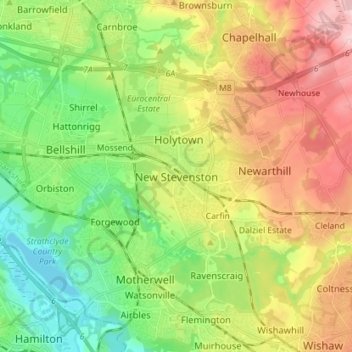
Navn: Topografisk kort New Stevenston, højde, relief.
Gjennomsnittlig høyde: 99 m
Minste høyde: 17 m
Maksimal høyde: 216 m
Gi en donasjon
Andre topografiske kart
Klikk på et kart for å se dets topografi, dets høyde og dets relieff.
Cumbernauld
United Kingdom > Scotland > North Lanarkshire
Cumbernauld's name probably comes from the Gaelic comar nan allt, meaning "meeting of the burns or streams". There are differing views as to the etymology of this. One theory is that from its high point in the Central Belt, its streams flow both west to the River Clyde and east to the Firth of Forth so…
Gjennomsnittlig høyde: 113 m
Strathclyde Park
United Kingdom > Scotland > North Lanarkshire > Motherwell
Gjennomsnittlig høyde: 44 m
Gi en donasjon
Forrestburn Reservoir
United Kingdom > Scotland > North Lanarkshire > Bentfoot
Gjennomsnittlig høyde: 231 m
Cumbernauld
United Kingdom > Scotland > North Lanarkshire
Cumbernauld's name probably comes from the Gaelic comar nan allt, meaning "meeting of the burns or streams". There are differing views as to the etymology of this. One theory is that from its high point in the Central Belt, its streams flow both west to the River Clyde and east to the Firth of Forth so…
Gjennomsnittlig høyde: 113 m