
Gi en donasjon
Topografisk kart Ceres
Klikk på kartet for å vise høyde.
Gi en donasjon
Om dette kartet
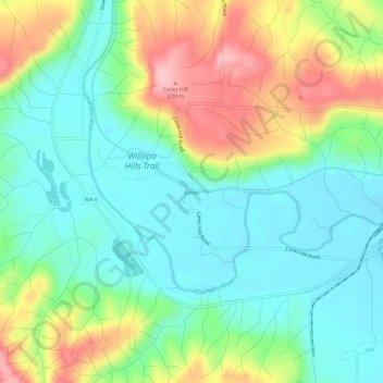
Navn: Topografisk kort Ceres, højde, relief.
Sted: Ceres, Lewis County, Washington, United States (46.58788 -123.17347 46.62788 -123.13347)
Gjennomsnittlig høyde: 123 m
Minste høyde: 59 m
Maksimal høyde: 247 m
Gi en donasjon
Andre topografiske kart
Klikk på et kart for å se dets topografi, dets høyde og dets relieff.
Gi en donasjon
Gi en donasjon
Gi en donasjon
Winlock
United States > Washington > Lewis County
The eastern edge of the Willapa Hills lie to the west. To the east are relatively flat prairies. A notable landmark about four miles west of town is Sam Henry Mountain, elevation 1,492 feet (455 m), named for an early section superintendent of the Northern Pacific Railroad. Mt. St. Helens, about forty miles…
Gjennomsnittlig høyde: 124 m
Gi en donasjon
Gi en donasjon
Winlock
United States > Washington > Lewis County
The eastern edge of the Willapa Hills lie to the west. To the east are relatively flat prairies. A notable landmark about four miles west of town is Sam Henry Mountain, elevation 1,492 feet (455 m), named for an early section superintendent of the Northern Pacific Railroad. Mt. St. Helens, about forty miles…
Gjennomsnittlig høyde: 124 m
Napavine
United States > Washington > Lewis County
A railroad depot was built in the late 1910s and provided passenger service until 1960. The Napavine Depot continued to serve the area until the station was permanently closed in April 1968 despite local protest. The Northern Pacific Railway station marked the highest elevation on the line between Portland and…
Gjennomsnittlig høyde: 105 m