
Gi en donasjon
Topografisk kart Canjilon Mountain
Klikk på kartet for å vise høyde.
Gi en donasjon
Om dette kartet
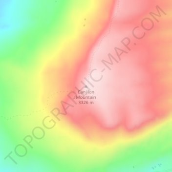
Navn: Topografisk kort Canjilon Mountain, højde, relief.
Gjennomsnittlig høyde: 3 186 m
Minste høyde: 2 984 m
Maksimal høyde: 3 326 m
Gi en donasjon
Andre topografiske kart
Klikk på et kart for å se dets topografi, dets høyde og dets relieff.
Espanola
United States > New Mexico > Rio Arriba County
Española lies at an elevation of around 5,595 feet (1,705 m) with much variance. It is in a valley nestled between the Jemez and Sangre de Cristo mountain ranges, and the meeting point of three rivers, the Rio Grande, the Rio Chama, and the Rio Santa Cruz.
Gjennomsnittlig høyde: 1 739 m
Dulce
United States > New Mexico > Rio Arriba County
Dulce is the southernmost urban area with a subarctic humid continental climate in North America (Köppen: Dfc) where summer is mild and short due to high altitude and rigorous winter. Going further south than the Dfb in low altitude and in latitude similar to the southern limit of the Dfa in the center of the…
Gjennomsnittlig høyde: 2 179 m
Gi en donasjon
Espanola
United States > New Mexico > Rio Arriba County
Española lies at an elevation of around 5,595 feet (1,705 m) with much variance. It is in a valley nestled between the Jemez and Sangre de Cristo mountain ranges, and the meeting point of three rivers, the Rio Grande, the Rio Chama, and the Rio Santa Cruz.
Gjennomsnittlig høyde: 1 739 m
Tierra Amarilla
United States > New Mexico > Rio Arriba County > Tierra Amarilla
Gjennomsnittlig høyde: 2 290 m
Espanola
United States > New Mexico > Rio Arriba County
Española lies at an elevation of around 5,595 feet (1,705 m) with much variance. It is in a valley nestled between the Jemez and Sangre de Cristo mountain ranges, and the meeting point of three rivers, the Rio Grande, the Rio Chama, and the Rio Santa Cruz.
Gjennomsnittlig høyde: 1 739 m