
Gi en donasjon
Topografisk kart Waters
Klikk på kartet for å vise høyde.
Gi en donasjon
Om dette kartet
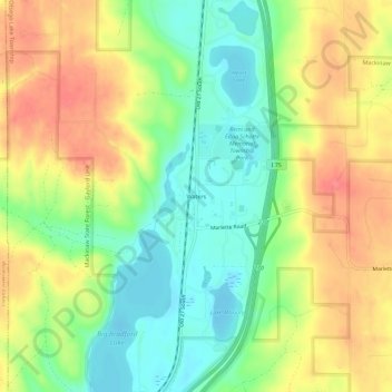
Navn: Topografisk kort Waters, højde, relief.
Gjennomsnittlig høyde: 414 m
Minste høyde: 378 m
Maksimal høyde: 454 m
Gi en donasjon
Andre topografiske kart
Klikk på et kart for å se dets topografi, dets høyde og dets relieff.
Pigeon River Country State Forest
United States > Michigan > Otsego County
Gjennomsnittlig høyde: 289 m
Gaylord
United States > Michigan > Otsego County
Gaylord became a city in 1922. The change from village to city required a vote by town residents. For reasons that are unclear, the margin of passage was a very close 21 votes — 114 people in favor to 93 against. John Hamilton was elected the first mayor of Gaylord. Over the years, the community continued to…
Gjennomsnittlig høyde: 401 m
Gi en donasjon
Gaylord
United States > Michigan > Otsego County
Gaylord sees significant snowfall during winter due to its elevation and its location in the path of lake-effect snow produced by Lake Michigan. Combined with local terrain and topography, many winter recreation opportunities abound.
Gjennomsnittlig høyde: 401 m
Gi en donasjon
Pigeon River Country State Forest
United States > Michigan > Otsego County
Gjennomsnittlig høyde: 289 m
Gaylord
United States > Michigan > Otsego County
Gaylord sees significant snowfall during winter due to its elevation and its location in the path of lake-effect snow produced by Lake Michigan. Combined with local terrain and topography, many winter recreation opportunities abound.
Gjennomsnittlig høyde: 401 m
Gi en donasjon