
Takk for at du støtter denne siden ❤️
Gi en donasjon
Gi en donasjon
Topografisk kart Red Rock
Klikk på kartet for å vise høyde.
Takk for at du støtter denne siden ❤️
Gi en donasjon
Gi en donasjon
Om dette kartet
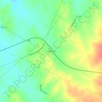
Navn: Topografisk kort Red Rock, højde, relief.
Sted: Red Rock, Bastrop County, Texas, 78662, United States (29.93967 -97.46611 29.97967 -97.42611)
Gjennomsnittlig høyde: 152 m
Minste høyde: 130 m
Maksimal høyde: 183 m
Takk for at du støtter denne siden ❤️
Gi en donasjon
Gi en donasjon
Andre topografiske kart
Klikk på et kart for å se dets topografi, dets høyde og dets relieff.