
Gi en donasjon
Topografisk kart Sainte-Ode
Klikk på kartet for å vise høyde.
Gi en donasjon
Om dette kartet
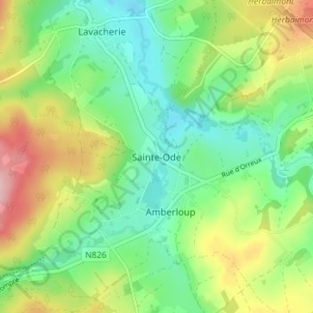
Navn: Topografisk kort Sainte-Ode, højde, relief.
Gjennomsnittlig høyde: 418 m
Minste høyde: 356 m
Maksimal høyde: 528 m
Gi en donasjon
Andre topografiske kart
Klikk på et kart for å se dets topografi, dets høyde og dets relieff.
Bastogne
Belgium > Luxembourg > Bastogne
The municipality consists of the following districts: Bastogne, Longvilly, Noville, Villers-la-Bonne-Eau, and Wardin. The town is situated on a ridge in the Ardennes at an elevation of 510 metres (1,670 ft).
Gjennomsnittlig høyde: 464 m
Gi en donasjon
Gi en donasjon
Bastogne
Belgium > Luxembourg > Bastogne
The municipality consists of the following districts: Bastogne, Longvilly, Noville, Villers-la-Bonne-Eau, and Wardin. The town is situated on a ridge in the Ardennes at an elevation of 510 metres (1,670 ft).
Gjennomsnittlig høyde: 464 m
Gi en donasjon
Bastogne
Belgium > Luxembourg > Bastogne
The municipality consists of the following districts: Bastogne, Longvilly, Noville, Villers-la-Bonne-Eau, and Wardin. The town is situated on a ridge in the Ardennes at an elevation of 510 metres (1,670 ft).
Gjennomsnittlig høyde: 464 m
Gi en donasjon