
Gi en donasjon
Topografisk kart Millport
Klikk på kartet for å vise høyde.
Gi en donasjon
Om dette kartet
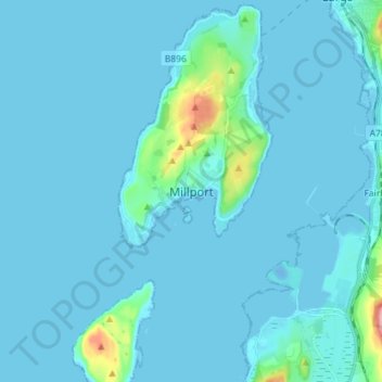
Navn: Topografisk kort Millport, højde, relief.
Sted: Millport, North Ayrshire, Scotland, KA28 0DL, United Kingdom (55.71396 -4.96398 55.79396 -4.88398)
Gjennomsnittlig høyde: 11 m
Minste høyde: -13 m
Maksimal høyde: 162 m
Gi en donasjon
Andre topografiske kart
Klikk på et kart for å se dets topografi, dets høyde og dets relieff.
Isle of Arran
United Kingdom > Scotland > North Ayrshire
The island has three endemic species of tree, the Arran whitebeams. These trees are the Scottish or Arran whitebeam (Sorbus arranensis), the bastard mountain ash or cut-leaved whitebeam (Sorbus pseudofennica) and the Catacol whitebeam (Sorbus pseudomeinichii). If rarity is measured by numbers alone they are…
Gjennomsnittlig høyde: 98 m
Gi en donasjon