
Gi en donasjon
Topografisk kart East Point
Klikk på kartet for å vise høyde.
Gi en donasjon
Om dette kartet
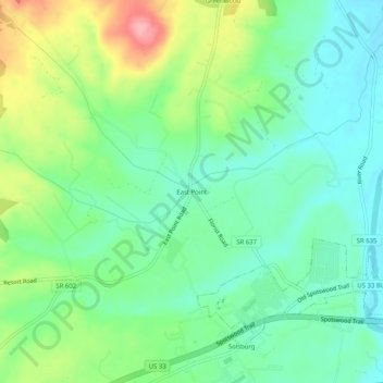
Navn: Topografisk kort East Point, højde, relief.
Gjennomsnittlig høyde: 320 m
Minste høyde: 280 m
Maksimal høyde: 402 m
Gi en donasjon
Andre topografiske kart
Klikk på et kart for å se dets topografi, dets høyde og dets relieff.
Port Republic
United States > Virginia > Rockingham County > Port Republic
Gjennomsnittlig høyde: 339 m
McGaheysville
United States > Virginia > Rockingham County > McGaheysville
Gjennomsnittlig høyde: 364 m
Gi en donasjon
Harrisonburg/Warm Springs Turnpike Park
United States > Virginia > Rockingham County > Bridgewater
Gjennomsnittlig høyde: 378 m
Port Republic
United States > Virginia > Rockingham County > Port Republic
Gjennomsnittlig høyde: 339 m
Gi en donasjon
Belmont Estates
United States > Virginia > Rockingham County > Belmont Estates
Gjennomsnittlig høyde: 410 m
Gi en donasjon
Bridgewater
United States > Virginia > Rockingham County
According to the United States Census Bureau, the town has a total area of 2.52 sq mi (6.5 km2), nearly all of it being land. Most of the town is located within a bend of the North River. Floods have wrecked the town occasionally. The northern areas are partly shielded from flooding with an Army Corps of…
Gjennomsnittlig høyde: 380 m