
Gi en donasjon
Topografisk kart La Paz
Klikk på kartet for å vise høyde.
Gi en donasjon
Om dette kartet
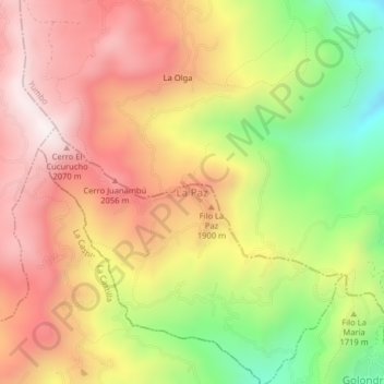
Navn: Topografisk kort La Paz, højde, relief.
Sted: La Paz, Cali, Sur, Valle del Cauca, RAP Pacífico, Colombia (3.50009 -76.58848 3.54009 -76.54848)
Gjennomsnittlig høyde: 1 762 m
Minste høyde: 1 257 m
Maksimal høyde: 2 165 m
Gi en donasjon
Andre topografiske kart
Klikk på et kart for å se dets topografi, dets høyde og dets relieff.
Cali
Colombia > Valle del Cauca > Cali
Under Köppen's climate classification, Cali features a dry-summer tropical monsoon climate (Köppen climate classification: Am), bordering a tropical savanna climate (Köppen: As). The Western Mountain Range rises from an average of 2,000 m (6,562 ft) above sea level in the northern part of the city to…
Gjennomsnittlig høyde: 1 140 m
Gi en donasjon
Cali
Colombia > Valle del Cauca > Cali
Under Köppen's climate classification, Cali features a dry-summer tropical savanna climate (Köppen climate classification: As). The Western Mountain Range rises from an average of 2,000 m (6,562 ft) above sea level in the northern part of the city to approximately 4,000 m (13,123 ft) to the south. Because of…
Gjennomsnittlig høyde: 1 142 m
Cali
Colombia > Valle del Cauca > Cali
Under Köppen's climate classification, Cali features a dry-summer tropical savanna climate (Köppen climate classification: As). The Western Mountain Range rises from an average of 2,000 m (6,562 ft) above sea level in the northern part of the city to approximately 4,000 m (13,123 ft) to the south. Because of…
Gjennomsnittlig høyde: 1 140 m
Gi en donasjon