
Takk for at du støtter denne siden ❤️
Gi en donasjon
Gi en donasjon
Topografisk kart Bidar
Klikk på kartet for å vise høyde.
Takk for at du støtter denne siden ❤️
Gi en donasjon
Gi en donasjon
Bidar
Bidar is located at 17°54′N 77°30′E / 17.9°N 77.5°E / 17.9; 77.5, lies at a central position in Deccan, a plateau at an elevation of 2300 ft from the sea level. It has common boundaries with Maharashtra and Telangana which is, with the districts of Nizamabad and Medak in Telangana on the East and the districts of Latur, Nanded and Osmanabad in Maharashtra on the west. On the south lies the district Gulbarga of Karnataka.
Takk for at du støtter denne siden ❤️
Gi en donasjon
Gi en donasjon
Om dette kartet
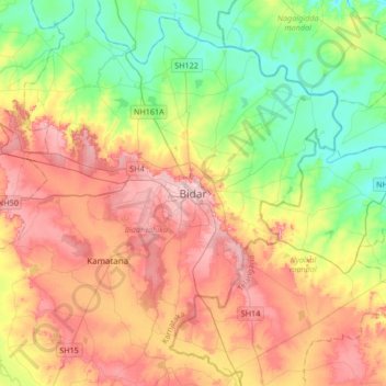
Navn: Topografisk kort Bidar, højde, relief.
Sted: Bidar, Bidar taluku, Bidar, Karnataka, 585400, India (17.75438 77.36636 18.07438 77.68636)
Gjennomsnittlig høyde: 593 m
Minste høyde: 520 m
Maksimal høyde: 680 m
Takk for at du støtter denne siden ❤️
Gi en donasjon
Gi en donasjon