
Gi en donasjon
Topografisk kart Temple
Klikk på kartet for å vise høyde.
Gi en donasjon
Om dette kartet
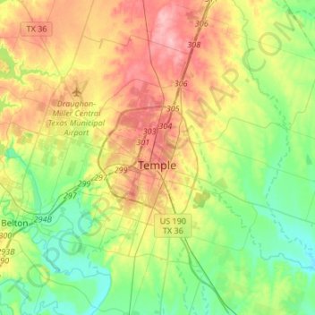
Navn: Topografisk kort Temple, højde, relief.
Sted: Temple, Bell County, Texas, United States (30.99817 -97.55804 31.20906 -97.29020)
Gjennomsnittlig høyde: 185 m
Minste høyde: 136 m
Maksimal høyde: 258 m
Gi en donasjon
Andre topografiske kart
Klikk på et kart for å se dets topografi, dets høyde og dets relieff.
Belton
United States > Texas > Bell County > Belton > Belton
Belton is located 60 miles (97 km) north of Austin, 137 miles (220 km) south of Dallas, and 184 miles (296 km) west of Houston. It is near the center of Bell County at 31°3′32″N 97°27′48″W / 31.05889°N 97.46333°W / 31.05889; -97.46333 (31.058904, -97.463382). It is at the point where the…
Gjennomsnittlig høyde: 176 m
Gi en donasjon
Belton
United States > Texas > Bell County
Belton is located 60 miles (97 km) north of Austin, 137 miles (220 km) south of Dallas, and 184 miles (296 km) west of Houston. It is near the center of Bell County at 31°3′32″N 97°27′48″W / 31.05889°N 97.46333°W / 31.05889; -97.46333 (31.058904, –97.463382). Belton is at the point where…
Gjennomsnittlig høyde: 179 m
Morgans Point Resort
United States > Texas > Bell County > Morgans Point Resort
Gjennomsnittlig høyde: 201 m
Gi en donasjon