
Gi en donasjon
Topografisk kart Mount Cleveland
Klikk på kartet for å vise høyde.
Gi en donasjon
Mount Cleveland
While not of great absolute elevation (the mountain is more than 2,300 ft (700 m) lower than Granite Peak, the highest peak in Montana), Mount Cleveland is notable for its large, steep rise above local terrain. For example, its west flank rises over 5,500 ft (1,700 m) in less than 2 mi (3.2 km); the northwest face, the steepest on the mountain, rises 4,000 ft (1,200 m) in less than 0.4 mi (0.64 km). The other faces show almost as much vertical relief. This scale and steepness of relief is quite rare in the contiguous United States. Mount Cleveland ranks 50th on the list of peaks in the contiguous U.S. with the greatest topographic prominence. The massif upon which Mount Cleveland is situated also includes 10,001-foot (3,048 m) Kaiser Point, which is the seventh-highest peak in the park and is only .67 mi (1.08 km) to the northeast.
Gi en donasjon
Om dette kartet
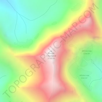
Navn: Topografisk kort Mount Cleveland, højde, relief.
Sted: Mount Cleveland, Glacier County, Montana, United States (48.92495 -113.84811 48.92505 -113.84801)
Gjennomsnittlig høyde: 2 339 m
Minste høyde: 1 639 m
Maksimal høyde: 3 173 m
Gi en donasjon
Andre topografiske kart
Klikk på et kart for å se dets topografi, dets høyde og dets relieff.
Gi en donasjon
Gi en donasjon
Gi en donasjon