
Gi en donasjon
Topografisk kart Speedwell
Klikk på kartet for å vise høyde.
Gi en donasjon
Om dette kartet
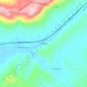
Navn: Topografisk kort Speedwell, højde, relief.
Gjennomsnittlig høyde: 416 m
Minste høyde: 328 m
Maksimal høyde: 710 m
Gi en donasjon
Andre topografiske kart
Klikk på et kart for å se dets topografi, dets høyde og dets relieff.
New Tazewell
United States > Tennessee > Claiborne County
When the railroad line was built from Knoxville through Cumberland Gap in the late 1880s, it bypassed the city of Tazewell. It is uncertain whether the railroad was unable to obtain right of way, or whether the decision was made because of topography, but the railroad depot was built about two miles to the…
Gjennomsnittlig høyde: 465 m
Gi en donasjon