
Takk for at du støtter denne siden ❤️
Gi en donasjon
Gi en donasjon
Topografisk kart Mount Baldhead
Klikk på kartet for å vise høyde.
Takk for at du støtter denne siden ❤️
Gi en donasjon
Gi en donasjon
Mount Baldhead
Mount Baldhead, also known as Mt. Baldy and Radar Hill, is a 250-foot (76-meter) sand dune located on a narrow strip of land between Lake Michigan and Kalamazoo River, directly across the river from downtown Saugatuck. It has an elevation of 807 feet (246 meters) and is about 70 miles (110 kilometers) north of the Indiana border on the west shore of Michigan in Allegan County.
Takk for at du støtter denne siden ❤️
Gi en donasjon
Gi en donasjon
Om dette kartet
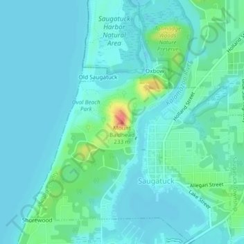
Navn: Topografisk kort Mount Baldhead, højde, relief.
Gjennomsnittlig høyde: 184 m
Minste høyde: 174 m
Maksimal høyde: 232 m
Takk for at du støtter denne siden ❤️
Gi en donasjon
Gi en donasjon