
Takk for at du støtter denne siden ❤️
Gi en donasjon
Gi en donasjon
Topografisk kart Superior
Klikk på kartet for å vise høyde.
Takk for at du støtter denne siden ❤️
Gi en donasjon
Gi en donasjon
Om dette kartet
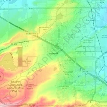
Navn: Topografisk kort Superior, højde, relief.
Sted: Superior, Boulder County, Colorado, 80027, United States (39.91276 -105.20860 39.99276 -105.12860)
Gjennomsnittlig høyde: 1 689 m
Minste høyde: 1 607 m
Maksimal høyde: 1 832 m
Takk for at du støtter denne siden ❤️
Gi en donasjon
Gi en donasjon
Andre topografiske kart
Klikk på et kart for å se dets topografi, dets høyde og dets relieff.
Nederland
United States > Colorado > Boulder County
In 1873 the Caribou Mine, at an elevation of roughly 10,000 feet (3,000 m) and 6 miles (10 km) northwest of the town, was sold to the Mining Company Nederland from the Netherlands. The high elevation meant fierce winds and deep winter snow, so the new owners of the mine decided that it was beneficial to bring…
Gjennomsnittlig høyde: 2 578 m
Takk for at du støtter denne siden ❤️
Gi en donasjon
Gi en donasjon