
Gi en donasjon
Topografisk kart Hamnafield
Klikk på kartet for å vise høyde.
Gi en donasjon
Om dette kartet
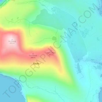
Navn: Topografisk kort Hamnafield, højde, relief.
Sted: Hamnafield, Shetland, Scotland, ZE2 9PN, United Kingdom (60.12711 -2.08517 60.14711 -2.06517)
Gjennomsnittlig høyde: 117 m
Minste høyde: -1 m
Maksimal høyde: 400 m
Gi en donasjon
Andre topografiske kart
Klikk på et kart for å se dets topografi, dets høyde og dets relieff.
Yell
United Kingdom > Scotland > Shetland
Yell is 19 miles (31 kilometres) in length, with a maximum breadth of 7.5 miles (12.1 kilometres), and is swept all around by very impetuous tides. The island extends northward to within 9.5 miles (15.3 kilometres) of the northwestern extremity of Unst. It is divided by only the narrow Bluemull Sound from the…
Gjennomsnittlig høyde: 27 m
Gi en donasjon
Gi en donasjon
Out Skerries
United Kingdom > Scotland > Shetland
Being so close to Norway, the islands were of strategic importance in World War II and were a regular landfall for Norwegian boats carrying escapees from the Nazi occupation. The local coastguard was responsible for the refugees, and at one point during the war were issued with a tommy gun, although initially…
Gjennomsnittlig høyde: 1 m
Gi en donasjon
Lerwick
United Kingdom > Scotland > Shetland
Lerwick has transitioned from a subpolar oceanic climate (Cfc) to a maritime climate (Cfb) with cool to cold temperatures all year long. The lack of trees reflects the latter type. This is particularly pronounced by virtue of Lerwick being on the coast of an island, so even extreme temperature records are…
Gjennomsnittlig høyde: 34 m
Gi en donasjon
Housay
United Kingdom > Scotland > Shetland
Being so close to Norway, the islands were of strategic importance in World War II and were a regular landfall for Norwegian boats carrying escapees from the Nazi occupation. The local coastguard was responsible for the refugees, and at one point during the war were issued with a tommy gun, although initially…
Gjennomsnittlig høyde: 3 m
Gi en donasjon