
Gi en donasjon
Topografisk kart Elsenborn
Klikk på kartet for å vise høyde.
Gi en donasjon
Om dette kartet
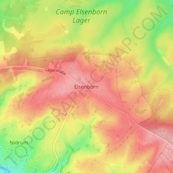
Navn: Topografisk kort Elsenborn, højde, relief.
Sted: Elsenborn, Verviers, Liège, Wallonia, 4750, Belgium (50.43731 6.20138 50.47731 6.24138)
Gjennomsnittlig høyde: 590 m
Minste høyde: 518 m
Maksimal høyde: 639 m
Gi en donasjon
Andre topografiske kart
Klikk på et kart for å se dets topografi, dets høyde og dets relieff.
Spa
Spa has an oceanic climate that is made more continental by its higher elevation and inland position compared to other Belgian climates at lower level or closer to the sea. Spa has a relatively high precipitation year round, with tricky weather something that the Spa-Francorchamps race track is known for. The…
Gjennomsnittlig høyde: 402 m
Eupen
Eupen has a cool oceanic climate with some continental influences due to it being elevated in comparison to most of Belgium. Eupen is also wetter and cloudier than Liège in the valley to the west, as a result of orographic lift due to the elevation change. As a result of this along with frequent winter…
Gjennomsnittlig høyde: 368 m
Gi en donasjon
Stavelot
Stavelot has an oceanic climate influenced by its high elevation and inland position towards a more continental type by Belgian standards. Being located at a lower elevation than neighbouring village Malmedy at the other end of the original layout of the Spa-Francorchamps race track, Stavelot is slightly…
Gjennomsnittlig høyde: 431 m
Gi en donasjon
Gi en donasjon
Spa
Spa has an oceanic climate that is made more continental by its higher elevation and inland position compared to other Belgian climates at lower level or closer to the sea. Spa has a relatively high precipitation year-round, with tricky weather something that the Spa-Francorchamps race track is known for. The…
Gjennomsnittlig høyde: 402 m
Spa
Spa has an oceanic climate that is made more continental by its higher elevation and inland position compared to other Belgian climates at lower level or closer to the sea. Spa has a relatively high precipitation year round, with tricky weather something that the Spa-Francorchamps race track is known for. The…
Gjennomsnittlig høyde: 402 m
Gi en donasjon
Malmedy
Malmedy has an oceanic climate with continental influences due to its inland position and higher elevation. Winter can see ice days, strong air frosts and snowfall. Malmedy's high precipitation is commonly affecting the nearby Spa-Francorchamps race track, known for its treacherous weather conditions.
Gjennomsnittlig høyde: 489 m
Gi en donasjon
Eupen
Eupen has a cool oceanic climate with some continental influences due to it being elevated in comparison to most of Belgium. Eupen is also wetter and cloudier than Liège in the valley to the west, as a result of orographic lift due to the elevation change. As a result of this along with frequent winter…
Gjennomsnittlig høyde: 368 m
Gi en donasjon
Spa
Spa has an oceanic climate that is made more continental by its higher elevation and inland position compared to other Belgian climates at lower level or closer to the sea. Spa has a relatively high precipitation year-round, with tricky weather something that the Spa-Francorchamps race track is known for. The…
Gjennomsnittlig høyde: 402 m
Gi en donasjon
Eupen
Eupen has a cool oceanic climate with some continental influences due to it being elevated in comparison to most of Belgium. Eupen is also wetter and cloudier than Liège in the valley to the west, as a result of orographic lift due to the elevation change. As a result of this along with frequent winter…
Gjennomsnittlig høyde: 368 m
Gi en donasjon
Malmedy
Malmedy has an oceanic climate with continental influences due to its inland position and higher elevation. Winter can see ice days, strong air frosts and snowfall. Malmedy's high precipitation is commonly affecting the nearby Spa-Francorchamps race track, known for its treacherous weather conditions.
Gjennomsnittlig høyde: 489 m
Eupen
Eupen has a cool oceanic climate with some continental influences due to it being elevated in comparison to most of Belgium. Eupen is also wetter and cloudier than Liège in the valley to the west, as a result of orographic lift due to the elevation change. As a result of this along with frequent winter…
Gjennomsnittlig høyde: 368 m
Gi en donasjon
Gi en donasjon
Gi en donasjon