
Gi en donasjon
Topografisk kart The Carousel
Klikk på kartet for å vise høyde.
Gi en donasjon
Om dette kartet
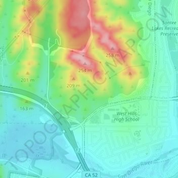
Navn: Topografisk kort The Carousel, højde, relief.
Gjennomsnittlig høyde: 137 m
Minste høyde: 85 m
Maksimal høyde: 251 m
Gi en donasjon
Andre topografiske kart
Klikk på et kart for å se dets topografi, dets høyde og dets relieff.
Cabrillo National Monument
United States > California > San Diego County > San Diego
The Old Point Loma Lighthouse is the highest point in the park and has been a San Diego icon since 1855. The lighthouse was closed in 1891, and the New Point Loma Lighthouse opened at a lower elevation, as fog and low clouds often obscured the light at its location 129 meters (422 feet) above sea level. The…
Gjennomsnittlig høyde: 13 m
San Diego River
United States > California > San Diego County > San Diego
Gjennomsnittlig høyde: 133 m
Gi en donasjon
Lake Murray Reservoir
United States > California > San Diego County > San Diego > San Carlos
Gjennomsnittlig høyde: 178 m
Gi en donasjon
Torrey Pines State Natural Reserve
United States > California > San Diego County > San Diego
Gjennomsnittlig høyde: 37 m
Los Peñasquitos Canyon Preserve
United States > California > San Diego County > San Diego > Sorrento Valley
Gjennomsnittlig høyde: 95 m