
Gi en donasjon
Topografisk kart Apostle Islands
Klikk på kartet for å vise høyde.
Gi en donasjon
Om dette kartet
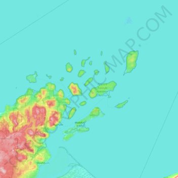
Navn: Topografisk kort Apostle Islands, højde, relief.
Sted: Apostle Islands, Wisconsin, United States (46.61827 -90.97296 47.25827 -90.33296)
Gjennomsnittlig høyde: 197 m
Minste høyde: 175 m
Maksimal høyde: 431 m
Gi en donasjon
Andre topografiske kart
Klikk på et kart for å se dets topografi, dets høyde og dets relieff.
Milwaukee
United States > Wisconsin > Milwaukee County
Milwaukee County is characterized by a gently rolling landscape that transitions into flatter terrain as it approaches Lake Michigan. The region's elevation varies modestly, with most areas ranging from about 600 to 700 feet above sea level. The county features several prominent water bodies, including the…
Gjennomsnittlig høyde: 205 m
Gi en donasjon
Madison
United States > Wisconsin > Dane County
The city is sometimes described as The City of Four Lakes, comprising the four successive lakes of the Yahara River: Lake Mendota ("Fourth Lake"), Lake Monona ("Third Lake"), Lake Waubesa ("Second Lake") and Lake Kegonsa ("First Lake"), although Waubesa and Kegonsa are not actually in Madison, but just south…
Gjennomsnittlig høyde: 284 m
Door County
The 102-foot-high (31 m) Brussels Hill (44°45′06″N 87°35′27″W / 44.75166°N 87.59093°W / 44.75166; -87.59093 (Brussels Hill), elevation 851 feet [259 m]) is the highest point in the county. The nearby Red Hill Woods is the largest remaining maple–beech forest in the area.
Gjennomsnittlig høyde: 202 m
Gi en donasjon
Madison
United States > Wisconsin > Dane County
The city is sometimes described as The City of Four Lakes, comprising the four successive lakes of the Yahara River: Lake Mendota ("Fourth Lake"), Lake Monona ("Third Lake"), Lake Waubesa ("Second Lake") and Lake Kegonsa ("First Lake"), although Waubesa and Kegonsa are not actually in Madison, but just south…
Gjennomsnittlig høyde: 284 m
Gi en donasjon
Dane County
Dane County showcases a diverse topography characterized by its rolling hills and numerous lakes, primarily shaped by glacial activity during the last Ice Age. The terrain varies significantly, with elevations ranging from approximately 860 feet to 1,200 feet above sea level. The county is famously known for…
Gjennomsnittlig høyde: 289 m
Wausau
United States > Wisconsin > Marathon County
According to the United States Census Bureau, the city has a total area of 20.33 square miles (52.7 km2), of which 19.22 square miles (49.8 km2) is land and 1.11 square miles (2.9 km2) is water. The city is located at an altitude of 1,195 feet (364 m). Wausau is close to the center of the northern half of the…
Gjennomsnittlig høyde: 394 m
Gi en donasjon
Gi en donasjon
Gi en donasjon
Devil's Lake State Park
United States > Wisconsin > Sauk County > Town of Baraboo
Gjennomsnittlig høyde: 335 m
Gi en donasjon
Janesville
United States > Wisconsin > Rock County
According to the United States Census Bureau, the city has a total area of 34.76 square miles (90.03 km2), of which 34.16 square miles (88.47 km2) is land and 0.6 square miles (1.55 km2) is water. The city is divided by the Rock River. Elevation is 837 ft, or 255 m.
Gjennomsnittlig høyde: 264 m
Gi en donasjon
Gi en donasjon
Gi en donasjon
Gi en donasjon
La Crosse
United States > Wisconsin > La Crosse County
Surrounding the relatively flat prairie valley where La Crosse lies are towering 500-foot (150 m) bluffs, one of the most prominent of which is Grandad Bluff (mentioned in Life on the Mississippi by Mark Twain), which has an overlook of the three states region. This feature typifies the topography of the…
Gjennomsnittlig høyde: 238 m
West Bend
United States > Wisconsin > Washington County
West Bend is in the Kettle Moraine region, and its topography is varied. The glacial activity has formed many kettles and hills throughout the region.
Gjennomsnittlig høyde: 298 m
Gi en donasjon
Forest County
According to the U.S. Census Bureau, the county has a total area of 1,046 square miles (2,710 km2), of which 1,014 square miles (2,630 km2) is land and 32 square miles (83 km2) (3.1%) is water. The second highest elevation in the state of Wisconsin is Sugarbush hill which is in Forest County.
Gjennomsnittlig høyde: 479 m
Gi en donasjon
Gi en donasjon
Mount Horeb
United States > Wisconsin > Dane County
Located in Southwest Wisconsin, Mount Horeb is situated in a region referred to as the Driftless Area. While including parts of eastern Minnesota, northeastern Iowa, and northwest Illinois, the Driftless Area is widely regarded as a distinct feature to the Wisconsin landscape, stretching across eighteen…
Gjennomsnittlig høyde: 357 m
Gi en donasjon
Gi en donasjon
Gi en donasjon
Gi en donasjon
Gi en donasjon
Gi en donasjon
Gi en donasjon
Platteville
United States > Wisconsin > Grant County
Platteville is the largest city in Grant County in southwestern Wisconsin. The population was 11,836 at the 2020 census, up from 11,224 at the 2010 census. Much of this growth is likely due to the enrollment increase of the University of Wisconsin–Platteville. It is the principal city of the Platteville…
Gjennomsnittlig høyde: 295 m
Sussex
United States > Wisconsin > Waukesha County
Sussex is a village in Waukesha County, Wisconsin, United States, about 19 miles (31 km) northwest of Milwaukee and 9 miles (14 km) north of Waukesha. The village is 7.24 square miles (19 km2) at an elevation of 930 feet. The population was 11,487 at the 2020 census. It is part of the Milwaukee metropolitan…
Gjennomsnittlig høyde: 286 m
Gi en donasjon
Sun Prairie
United States > Wisconsin > Dane County
The landscape of the city consists mostly of gently rolling hills and plains. The elevation of the city averages about 984 feet (300 m) above mean sea level.
Gjennomsnittlig høyde: 293 m
Gi en donasjon
Gi en donasjon
Gi en donasjon