
Gi en donasjon
Topografisk kart Morristown
Klikk på kartet for å vise høyde.
Gi en donasjon
Om dette kartet
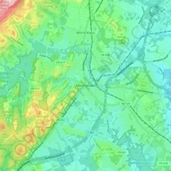
Navn: Topografisk kort Morristown, højde, relief.
Sted: Morristown, Morris County, New Jersey, 07960, United States (40.75704 -74.52099 40.83704 -74.44099)
Gjennomsnittlig høyde: 123 m
Minste høyde: 60 m
Maksimal høyde: 316 m
Gi en donasjon
Andre topografiske kart
Klikk på et kart for å se dets topografi, dets høyde og dets relieff.
Rainbow Lakes
United States > New Jersey > Morris County > Parsippany-Troy Hills
Gjennomsnittlig høyde: 146 m
Gi en donasjon
Landing
United States > New Jersey > Morris County > Roxbury Township > Port Morris
Gjennomsnittlig høyde: 297 m
Gi en donasjon
Long Valley
United States > New Jersey > Morris County > Washington Township > Long Valley
Gjennomsnittlig høyde: 235 m
Gi en donasjon
Madison
United States > New Jersey > Morris County
Madison's historic railroad station was funded by the community which passed an ordinance authorizing $159,000 for railroad improvement bonds. The result with the cooperation of the D.L. & W.R.R. in the planning was completed in 1916. The tracks were elevated through the downtown and no established roadways…
Gjennomsnittlig høyde: 88 m
Parsippany
United States > New Jersey > Morris County > Parsippany-Troy Hills > Lake Hiawatha
Gjennomsnittlig høyde: 86 m
Gi en donasjon
Brookside
United States > New Jersey > Morris County > Mendham Township > Brookside
Gjennomsnittlig høyde: 173 m
Boonton Reservoir
United States > New Jersey > Morris County > Parsippany-Troy Hills > Lake Hiawatha
Gjennomsnittlig høyde: 102 m
Gi en donasjon
Gi en donasjon
Gi en donasjon
Kinnelon
United States > New Jersey > Morris County
The highest mountain in Kinnelon is Kitty Ann Mountain. Located in Smoke Rise, the mountain offers views of northern New Jersey at an elevation of 1,140 feet (350 m) from the Smoke Rise Tower.
Gjennomsnittlig høyde: 196 m
Gi en donasjon
Chatham
United States > New Jersey > Morris County
The Passaic River, which rises at Millington Gorge in Long Hill Township and defines the Great Swamp, flows north along the eastern boundary of Chatham. A good crossing location, identified by Native Americans to early European settlers, figured significantly in the colonial history of the community. Fairmount…
Gjennomsnittlig høyde: 76 m
Flanders
United States > New Jersey > Morris County > Mount Olive > Flanders
Gjennomsnittlig høyde: 276 m
Green Village
United States > New Jersey > Morris County > Chatham Township
Gjennomsnittlig høyde: 81 m
Gi en donasjon
Powder Mill Pond Dam
United States > New Jersey > Morris County > Parsippany-Troy Hills > Tabor
Gjennomsnittlig høyde: 178 m
Oak Ridge
United States > New Jersey > Morris County > Jefferson Township
Green Pond Mountain, rising to over 1,260 feet (380 m) above sea level, forms the southern border of Oak Ridge and the border with Rockaway Township. Bowling Green Mountain, elevation 1,380 feet (420 m), borders the community to the southwest.
Gjennomsnittlig høyde: 306 m
Lake Hopatcong
United States > New Jersey > Morris County > Jefferson Township
Gjennomsnittlig høyde: 301 m
Gi en donasjon
Boonton Reservoir
United States > New Jersey > Morris County > Parsippany-Troy Hills
Gjennomsnittlig høyde: 102 m
Gi en donasjon
Green Village
United States > New Jersey > Morris County > Chatham Township
Gjennomsnittlig høyde: 81 m
Flanders
United States > New Jersey > Morris County > Mount Olive > Flanders
Gjennomsnittlig høyde: 276 m
Landing
United States > New Jersey > Morris County > Roxbury Township > Port Morris
Gjennomsnittlig høyde: 297 m
Mine Hill
United States > New Jersey > Morris County
According to the United States Census Bureau, the township had a total area of 3.00 square miles (7.76 km2), including 2.94 square miles (7.61 km2) of land and 0.06 square miles (0.15 km2) of water (1.93%). The township is at an elevation of 863 feet (263 m) above sea level for the administrative center.
Gjennomsnittlig høyde: 245 m
Gi en donasjon
Pine Brook
United States > New Jersey > Morris County > Montville Township > Pine Brook
Pine Brook is located in eastern Morris County, at the southern end of Montville Township. The center of the community sits in the Pine Brook Flats, a plain created by the surrounding Rockaway River and Passaic River. The northern part of the CDP lies on a ridge that continues north as Towakhow Mountain, with…
Gjennomsnittlig høyde: 58 m
Chatham
United States > New Jersey > Morris County
The Passaic River, which rises at Millington Gorge in Long Hill Township and defines the Great Swamp, flows north along the eastern boundary of Chatham. A good crossing location, identified by Native Americans to early European settlers, figured significantly in the colonial history of the community. Fairmount…
Gjennomsnittlig høyde: 76 m
Gi en donasjon
Brookside
United States > New Jersey > Morris County > Mendham Township > Brookside
Gjennomsnittlig høyde: 173 m
Mooney Mountain Park
United States > New Jersey > Morris County > Roxbury Township
Gjennomsnittlig høyde: 326 m
Gi en donasjon
Madison
United States > New Jersey > Morris County
Madison's historic railroad station was funded by the community, which passed an ordinance authorizing $159,000 for railroad improvement bonds. The result, with the cooperation of the D.L. & W.R.R. in the planning, was completed in 1916. The tracks were elevated through the downtown so that no established…
Gjennomsnittlig høyde: 88 m
Gi en donasjon
Parsippany
United States > New Jersey > Morris County > Parsippany-Troy Hills > Lake Hiawatha
Gjennomsnittlig høyde: 86 m
Parsippany
United States > New Jersey > Morris County > Parsippany-Troy Hills > Lake Hiawatha
Gjennomsnittlig høyde: 86 m
Kinnelon
United States > New Jersey > Morris County
The highest mountain in Kinnelon is Kitty Ann Mountain. Located in Smoke Rise, the mountain offers views of northern New Jersey at an elevation of 1,140 feet (350 m) from the Smoke Rise Tower.
Gjennomsnittlig høyde: 196 m
Gi en donasjon
Gi en donasjon
Landing
United States > New Jersey > Morris County > Roxbury Township > Port Morris
Gjennomsnittlig høyde: 297 m
Gi en donasjon
Great Swamp National Wildlife Refuge
United States > New Jersey > Morris County > Harding Township
The Great Swamp is the remnant of the bottom of the once-mighty Glacial Lake Passaic that approximately 15,000 to 11,000 years ago stretched across 30 by 10 miles (48 by 16 km) in what is presently northern New Jersey. The lake was formed by the melting waters of the retreating Wisconsin Glacier at the end of…
Gjennomsnittlig høyde: 85 m
Gi en donasjon
Lake Hiawatha
United States > New Jersey > Morris County > Parsippany-Troy Hills > Lake Hiawatha
Gjennomsnittlig høyde: 79 m
Gi en donasjon
Long Valley
United States > New Jersey > Morris County > Washington Township
Gjennomsnittlig høyde: 235 m
Gi en donasjon
Cedar Knolls
United States > New Jersey > Morris County > Hanover Township
Gjennomsnittlig høyde: 104 m
Gi en donasjon
Rockaway River Wildlife Management Area
United States > New Jersey > Morris County > Jefferson Township
Gjennomsnittlig høyde: 276 m
Gi en donasjon
Madison
United States > New Jersey > Morris County
Madison's historic railroad station was funded by the community which passed an ordinance authorizing $159,000 for railroad improvement bonds. The result with the cooperation of the D.L. & W.R.R. in the planning was completed in 1916. The tracks were elevated through the downtown and no established roadways…
Gjennomsnittlig høyde: 88 m
Chatham
United States > New Jersey > Morris County
The Passaic River, which rises at Millington Gorge in Long Hill Township and defines the Great Swamp, flows north along the eastern boundary of Chatham. A good crossing location, identified by Native Americans to early European settlers, figured significantly in the colonial history of the community. Fairmount…
Gjennomsnittlig høyde: 76 m
Gi en donasjon
Roxbury Township
United States > New Jersey > Morris County > Roxbury Township
Gjennomsnittlig høyde: 268 m
Gi en donasjon