Geolokaliser

Topografisk kart Tug Hill

Klikk på kartet for å vise høyde.

Tug Hill

The core Tug Hill region encompasses 150,000 acres (610 km2) of unbroken, generally second-growth, northern hardwood forest, and is drained by a vast network of streams. Important rivers and streams whose headwaters are located within the Tug Hill region include the Mohawk River, Deer River, Salmon River, Mad River, Sandy Creek, and the east and west branches of Fish Creek. Despite the presence of numerous streams, many of the soils in the regions' core are poorly drained. Almost all the soils have some combination of factors which render them unsuitable for agriculture, including shallow depth, stoniness, rough topography, poor or excessive drainage, strong acidity and/or low fertility. Agricultural activity is largely absent from the Tug Hill's core, and is concentrated mainly in the outlying northern and western portions of the region, where soils are better drained and more fertile.

Wikipedia (CC-BY-SA 3.0)

Om dette kartet

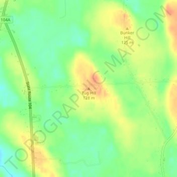
Navn: Topografisk kort Tug Hill, højde, relief.

Sted: Tug Hill, Town of Oswego, Oswego County, New York, United States (43.39835 -76.56083 43.39845 -76.56073)

Gjennomsnittlig høyde: 109 m

Minste høyde: 89 m

Maksimal høyde: 129 m

Andre topografiske kart

Klikk på et kart for å se dets topografi, dets høyde og dets relieff.

Town of New Haven

United States > New York > Oswego County

Gjennomsnittlig høyde: 114 m

Village of Pulaski

United States > New York > Oswego County

Gjennomsnittlig høyde: 117 m

Town of Schroeppel

United States > New York > Oswego County

Gjennomsnittlig høyde: 122 m

Village of Pulaski

United States > New York > Oswego County

Gjennomsnittlig høyde: 117 m

Town of West Monroe

United States > New York > Oswego County

Gjennomsnittlig høyde: 138 m

Town of Scriba

United States > New York > Oswego County

Gjennomsnittlig høyde: 105 m

Town of Richland

United States > New York > Oswego County

Gjennomsnittlig høyde: 178 m

Village of Parish

United States > New York > Oswego County

Gjennomsnittlig høyde: 147 m

Village of Sandy Creek

United States > New York > Oswego County

Gjennomsnittlig høyde: 152 m

Village of Mexico

United States > New York > Oswego County

Gjennomsnittlig høyde: 117 m

City of Fulton

United States > New York > Oswego County

Gjennomsnittlig høyde: 114 m

Town of Oswego

United States > New York > Oswego County

Gjennomsnittlig høyde: 97 m

Altmar

United States > New York > Oswego County

Gjennomsnittlig høyde: 175 m

Town of Schroeppel

United States > New York > Oswego County

Gjennomsnittlig høyde: 122 m

Town of Constantia

United States > New York > Oswego County

Gjennomsnittlig høyde: 137 m

Town of Scriba

United States > New York > Oswego County

Gjennomsnittlig høyde: 105 m

Town of Redfield

United States > New York > Oswego County

Gjennomsnittlig høyde: 395 m

Town of Orwell

United States > New York > Oswego County

Gjennomsnittlig høyde: 227 m

Town of Mexico

United States > New York > Oswego County

Gjennomsnittlig høyde: 119 m

City of Fulton

United States > New York > Oswego County

Gjennomsnittlig høyde: 114 m

Town of Mexico

United States > New York > Oswego County

Gjennomsnittlig høyde: 119 m

Town of Granby

United States > New York > Oswego County

Gjennomsnittlig høyde: 125 m

Town of Williamstown

United States > New York > Oswego County

Gjennomsnittlig høyde: 235 m