
Gi en donasjon
Topografisk kart Donges Bay
Klikk på kartet for å vise høyde.
Gi en donasjon
Om dette kartet
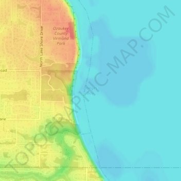
Navn: Topografisk kort Donges Bay, højde, relief.
Sted: Donges Bay, Ozaukee County, Wisconsin, 53092, United States (43.20357 -87.89430 43.20367 -87.89420)
Gjennomsnittlig høyde: 190 m
Minste høyde: 171 m
Maksimal høyde: 225 m
Gi en donasjon
Andre topografiske kart
Klikk på et kart for å se dets topografi, dets høyde og dets relieff.
Port Washington
United States > Wisconsin > Ozaukee County
The city is located on the western shore of Lake Michigan. In northern and southern parts of the city, the coastline is characterized by clay bluffs ranging from 80 feet (24 meters) to 130 feet (40 meters) in height with deep ravines where streams flow into the lake. Clay bluffs are a geological formation…
Gjennomsnittlig høyde: 201 m
Gi en donasjon
Port Washington
United States > Wisconsin > Ozaukee County
The city is located on the western shore of Lake Michigan. In northern and southern parts of the city, the coastline is characterized by clay bluffs ranging from 80 feet (24 meters) to 130 feet (40 meters) in height with deep ravines where streams flow into the lake. Clay bluffs are a geological formation…
Gjennomsnittlig høyde: 205 m
Gi en donasjon