
Gi en donasjon
Topografisk kart Hayden
Klikk på kartet for å vise høyde.
Gi en donasjon
Om dette kartet
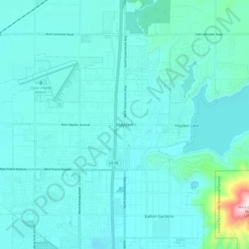
Navn: Topografisk kort Hayden, højde, relief.
Sted: Hayden, Kootenai County, Idaho, 83835, United States (47.71906 -116.82668 47.79906 -116.74668)
Gjennomsnittlig høyde: 717 m
Minste høyde: 654 m
Maksimal høyde: 1 250 m
Gi en donasjon
Andre topografiske kart
Klikk på et kart for å se dets topografi, dets høyde og dets relieff.
Coeur d'Alene
United States > Idaho > Kootenai County
The city is located on the north shore of Lake Coeur d'Alene, near the outlet of the Spokane River, and is in the Northern Rockies ecoregion. Lake Coeur d'Alene is a natural dam-controlled lake that is 25 miles (40 km) long and 1 mile (1.6 km) to 3 miles (4.8 km) wide and fed by the Coeur d'Alene and Saint Joe…
Gjennomsnittlig høyde: 719 m
Post Falls
United States > Idaho > Kootenai County
Post Falls features a varied and distinctive topography characterized by its placement on the Rathdrum Prairie, which lies at an elevation of approximately 2,182 feet (665 meters) above sea level. This prairie is surrounded by rolling hills and rugged terrain that gradually rise towards the nearby Rocky…
Gjennomsnittlig høyde: 710 m
Coeur d'Alene
United States > Idaho > Kootenai County
The city is located on the north shore of Lake Coeur d'Alene, near the outlet of the Spokane River, and is in the Northern Rockies ecoregion. Lake Coeur d'Alene is a natural dam-controlled lake that is 25 miles (40 km) long and 1 mile (1.6 km) to 3 miles (4.8 km) wide and fed by the Coeur d'Alene and Saint Joe…
Gjennomsnittlig høyde: 719 m
Rathdrum
United States > Idaho > Kootenai County
Rathdrum is located on the Rathdrum Prairie at 47°48′30″N 116°53′33″W / 47.80833°N 116.89250°W / 47.80833; -116.89250 (47.808457, -116.892415), at an elevation of 2,211 feet (674 m) above sea level.
Gjennomsnittlig høyde: 701 m
Gi en donasjon
Spirit Lake
United States > Idaho > Kootenai County
Spirit Lake is located at 47°58′00″N 116°51′59″W / 47.966592°N 116.866383°W / 47.966592; -116.866383, at an elevation of 2,569 feet (783 m) above sea level.
Gjennomsnittlig høyde: 780 m
Athol
United States > Idaho > Kootenai County
Athol is located at 47°56′46″N 116°42′26″W / 47.94611°N 116.70722°W / 47.94611; -116.70722 (47.946024, -116.707349), at an elevation of 2,392 feet (729 m) above sea level.
Gjennomsnittlig høyde: 733 m
Hayden
United States > Idaho > Kootenai County
According to the United States Census Bureau, the city has a total area of 9.61 square miles (24.89 km2), of which 9.60 square miles (24.86 km2) is land and 0.01 square miles (0.03 km2) is water. It lies at the southwestern end of Hayden Lake, and the elevation of the city is 2,287 feet (697 m) above sea level.
Gjennomsnittlig høyde: 709 m
Gi en donasjon
Post Falls
United States > Idaho > Kootenai County
Post Falls is located on the Rathdrum Prairie, along the Washington–Idaho border. It is bounded by Coeur d’Alene to the east, Stateline and the state of Washington to the west, and the Spokane River to the south. Post Falls is 20 miles (32 km) east of Spokane and approximately 100 miles (160 km) south of…
Gjennomsnittlig høyde: 710 m
Coeur d'Alene
United States > Idaho > Kootenai County
The city is located on the north shore of Lake Coeur d'Alene, near the outlet of the Spokane River, and is in the Northern Rockies ecoregion. Lake Coeur d'Alene is a natural dam-controlled lake that is 25 miles (40 km) long and 1 mile (1.6 km) to 3 miles (4.8 km) wide and fed by the Coeur d'Alene and Saint Joe…
Gjennomsnittlig høyde: 719 m
Gi en donasjon
Coeur d'Alene
United States > Idaho > Kootenai County
The city is located on the north shore of Lake Coeur d'Alene, near the outlet of the Spokane River, and is in the Northern Rockies ecoregion. Lake Coeur d'Alene is a natural dam-controlled lake that is 25 miles (40 km) long and 1 mile (1.6 km) to 3 miles (4.8 km) wide and fed by the Coeur d'Alene and Saint Joe…
Gjennomsnittlig høyde: 719 m
Athol
United States > Idaho > Kootenai County
Athol is located at 47°56′46″N 116°42′26″W / 47.94611°N 116.70722°W / 47.94611; -116.70722 (47.946024, -116.707349), at an elevation of 2,392 feet (729 m) above sea level.
Gjennomsnittlig høyde: 733 m
Gi en donasjon
Post Falls
United States > Idaho > Kootenai County
Post Falls is located on the Rathdrum Prairie, along the Washington–Idaho border. It is bounded by Coeur d’Alene to the east, Stateline and the state of Washington to the west, and the Spokane River to the south. Post Falls is 20 miles (32 km) east of Spokane and approximately 100 miles (160 km) south of…
Gjennomsnittlig høyde: 710 m
Rathdrum
United States > Idaho > Kootenai County
Rathdrum is located on the Rathdrum Prairie at 47°48′30″N 116°53′33″W / 47.80833°N 116.89250°W / 47.80833; -116.89250 (47.808457, -116.892415), at an elevation of 2,211 feet (674 m) above sea level.
Gjennomsnittlig høyde: 701 m