
Takk for at du støtter denne siden ❤️
Gi en donasjon
Gi en donasjon
Topografisk kart Maicao
Klikk på kartet for å vise høyde.
Takk for at du støtter denne siden ❤️
Gi en donasjon
Gi en donasjon
Maicao
The municipality of Maicao borders to the north with the municipalities of Uribia and Manaure; to the east with the Venezuela; to the south with the municipality of Albania and to the west with the municipality of Riohacha covering a total area of 1,782 km2 and at altitude over sea level of 52 m.
Takk for at du støtter denne siden ❤️
Gi en donasjon
Gi en donasjon
Om dette kartet
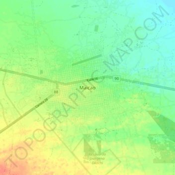
Navn: Topografisk kort Maicao, højde, relief.
Sted: Maicao, La Guajira, RAP Caribe, 442001, Colombia (11.33731 -72.27876 11.41731 -72.19876)
Gjennomsnittlig høyde: 51 m
Minste høyde: 34 m
Maksimal høyde: 73 m
Takk for at du støtter denne siden ❤️
Gi en donasjon
Gi en donasjon