
Gi en donasjon
Topografisk kart Mystic
Klikk på kartet for å vise høyde.
Gi en donasjon
Om dette kartet
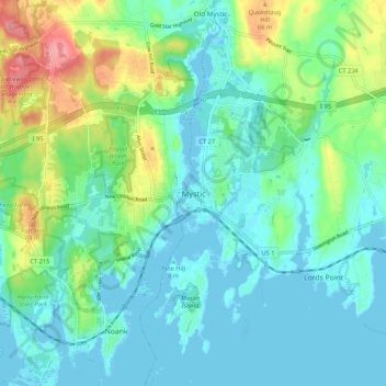
Navn: Topografisk kort Mystic, højde, relief.
Gjennomsnittlig høyde: 24 m
Minste høyde: -2 m
Maksimal høyde: 95 m
Gi en donasjon
Andre topografiske kart
Klikk på et kart for å se dets topografi, dets høyde og dets relieff.
Groton
United States > Connecticut > Southeastern Connecticut Planning Region
Gjennomsnittlig høyde: 21 m
Windham
United States > Connecticut > Southeastern Connecticut Planning Region
Gjennomsnittlig høyde: 103 m
Mystic
United States > Connecticut > Southeastern Connecticut Planning Region > Stonington > Mystic
Gjennomsnittlig høyde: 15 m
Waterford
United States > Connecticut > Southeastern Connecticut Planning Region
Gjennomsnittlig høyde: 30 m
Gi en donasjon
East Lyme
United States > Connecticut > Southeastern Connecticut Planning Region
The topography of East Lyme consists of rolling hills and lush valleys rounded by glaciers during the last Ice Age. Hills rise to elevations of 250 to 350 feet (76 to 107 m) above sea level in the eastern and central areas of the town. The highest point in town is an unnamed hill with an elevation of 500 feet…
Gjennomsnittlig høyde: 41 m
Taftville
United States > Connecticut > Southeastern Connecticut Planning Region > Norwich
Gjennomsnittlig høyde: 47 m
Austrailia Beach
United States > Connecticut > Southeastern Connecticut Planning Region > Mystic
Gjennomsnittlig høyde: 19 m
Old Mystic
United States > Connecticut > Southeastern Connecticut Planning Region > Groton > Old Mystic
Gjennomsnittlig høyde: 42 m
Gi en donasjon
Franklin
United States > Connecticut > Southeastern Connecticut Planning Region
Gjennomsnittlig høyde: 95 m
Austrailia Beach
United States > Connecticut > Southeastern Connecticut Planning Region > Mystic
Gjennomsnittlig høyde: 19 m
Franklin
United States > Connecticut > Southeastern Connecticut Planning Region
Gjennomsnittlig høyde: 95 m
Bozrah
United States > Connecticut > Southeastern Connecticut Planning Region
Gjennomsnittlig høyde: 97 m
Gi en donasjon
Salem
United States > Connecticut > Southeastern Connecticut Planning Region
Gjennomsnittlig høyde: 119 m
Ledyard
United States > Connecticut > Southeastern Connecticut Planning Region
Gjennomsnittlig høyde: 53 m
Gales Ferry
United States > Connecticut > Southeastern Connecticut Planning Region > Ledyard > Gales Ferry
Gjennomsnittlig høyde: 24 m
Colchester
United States > Connecticut > Southeastern Connecticut Planning Region
Gjennomsnittlig høyde: 134 m
Gi en donasjon
Norwich
United States > Connecticut > Southeastern Connecticut Planning Region
Gjennomsnittlig høyde: 63 m
New London
United States > Connecticut > Southeastern Connecticut Planning Region
Gjennomsnittlig høyde: 17 m
Lebanon
United States > Connecticut > Southeastern Connecticut Planning Region
Gjennomsnittlig høyde: 119 m
Windham
United States > Connecticut > Southeastern Connecticut Planning Region
Gjennomsnittlig høyde: 103 m
Gi en donasjon
Mystic
United States > Connecticut > Southeastern Connecticut Planning Region > Stonington > Mystic
Gjennomsnittlig høyde: 15 m
Ledyard
United States > Connecticut > Southeastern Connecticut Planning Region
Gjennomsnittlig høyde: 53 m
Montville
United States > Connecticut > Southeastern Connecticut Planning Region
Gjennomsnittlig høyde: 80 m
Taftville Reservoir #1 Dam
United States > Connecticut > Southeastern Connecticut Planning Region > Norwich
Gjennomsnittlig høyde: 75 m
Gi en donasjon
Montville
United States > Connecticut > Southeastern Connecticut Planning Region
Gjennomsnittlig høyde: 76 m
Sprague
United States > Connecticut > Southeastern Connecticut Planning Region
Gjennomsnittlig høyde: 79 m
Blue Lake
United States > Connecticut > Southeastern Connecticut Planning Region > North Stonington
Gjennomsnittlig høyde: 106 m
Thames River
United States > Connecticut > Southeastern Connecticut Planning Region > Waterford
Gjennomsnittlig høyde: 52 m
Gi en donasjon
New London
United States > Connecticut > Southeastern Connecticut Planning Region
Gjennomsnittlig høyde: 17 m
Salem
United States > Connecticut > Southeastern Connecticut Planning Region
Gjennomsnittlig høyde: 119 m
East Lyme
United States > Connecticut > Southeastern Connecticut Planning Region
The topography of East Lyme consists of rolling hills and lush valleys rounded by glaciers during the last Ice Age. Hills rise to elevations of 250 to 350 feet (76 to 107 m) above sea level in the eastern and central areas of the town. The highest point in town is an unnamed hill with an elevation of 500 feet…
Gjennomsnittlig høyde: 41 m
Austrailia Beach
United States > Connecticut > Southeastern Connecticut Planning Region > Mystic
Gjennomsnittlig høyde: 19 m
Gi en donasjon
Stonington
United States > Connecticut > Southeastern Connecticut Planning Region
Gjennomsnittlig høyde: 25 m
Bozrah
United States > Connecticut > Southeastern Connecticut Planning Region
Gjennomsnittlig høyde: 97 m
Norwich
United States > Connecticut > Southeastern Connecticut Planning Region
Gjennomsnittlig høyde: 63 m
New London
United States > Connecticut > Southeastern Connecticut Planning Region
Gjennomsnittlig høyde: 17 m
Gi en donasjon
Austrailia Beach
United States > Connecticut > Southeastern Connecticut Planning Region > Mystic
Gjennomsnittlig høyde: 19 m
Hanover Reservoir
United States > Connecticut > Southeastern Connecticut Planning Region > Hanover
Gjennomsnittlig høyde: 91 m
Preston
United States > Connecticut > Southeastern Connecticut Planning Region
Gjennomsnittlig høyde: 66 m
Willimantic
United States > Connecticut > Southeastern Connecticut Planning Region > Willimantic > Windham
Gjennomsnittlig høyde: 95 m
Gi en donasjon
Groton
United States > Connecticut > Southeastern Connecticut Planning Region
Gjennomsnittlig høyde: 19 m
North Stonington
United States > Connecticut > Southeastern Connecticut Planning Region
Gjennomsnittlig høyde: 73 m
Lisbon
United States > Connecticut > Southeastern Connecticut Planning Region
Gjennomsnittlig høyde: 64 m
Thames River
United States > Connecticut > Southeastern Connecticut Planning Region > Ledyard
Gjennomsnittlig høyde: 52 m
Gi en donasjon
Lebanon
United States > Connecticut > Southeastern Connecticut Planning Region
Gjennomsnittlig høyde: 119 m
North Stonington
United States > Connecticut > Southeastern Connecticut Planning Region
Gjennomsnittlig høyde: 78 m
Noank
United States > Connecticut > Southeastern Connecticut Planning Region > Groton > Noank
Gjennomsnittlig høyde: 15 m
Stonington
United States > Connecticut > Southeastern Connecticut Planning Region
Gjennomsnittlig høyde: 25 m
Gi en donasjon
Waterford
United States > Connecticut > Southeastern Connecticut Planning Region
Gjennomsnittlig høyde: 30 m
Harkness Memorial State Park
United States > Connecticut > Southeastern Connecticut Planning Region > Waterford
Gjennomsnittlig høyde: 12 m
Stonington
United States > Connecticut > Southeastern Connecticut Planning Region
Gjennomsnittlig høyde: 25 m
Groton
United States > Connecticut > Southeastern Connecticut Planning Region
Gjennomsnittlig høyde: 21 m
Gi en donasjon
Norwich
United States > Connecticut > Southeastern Connecticut Planning Region
Gjennomsnittlig høyde: 63 m