
Gi en donasjon
Topografisk kart Mount Graham
Klikk på kartet for å vise høyde.
Gi en donasjon
Om dette kartet
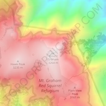
Navn: Topografisk kort Mount Graham, højde, relief.
Sted: Mount Graham, Graham County, Arizona, United States (32.70159 -109.87144 32.70169 -109.87134)
Gjennomsnittlig høyde: 2 957 m
Minste høyde: 2 446 m
Maksimal høyde: 3 260 m
Gi en donasjon
Andre topografiske kart
Klikk på et kart for å se dets topografi, dets høyde og dets relieff.
Safford
United States > Arizona > Graham County
The climate is cold semi-arid (Köppen: BSk) softened by the plateau rise (it receives enough rainfall not to fall into a cold desert, BWk). It is much hotter than most places in eastern Arizona due to its relatively low elevation of 2,953 feet (900 m) at the Agricultural Center where records are kept, and…
Gjennomsnittlig høyde: 912 m
Safford
United States > Arizona > Graham County
The climate is hot semi-arid (Köppen: BSh) softened by the plateau rise (it receives enough rainfall not to fall into a hot desert, BWh). It is much hotter than most places in eastern Arizona due to its relatively low elevation of 2,953 feet (900 m) at the Agricultural Center where records are kept, and often…
Gjennomsnittlig høyde: 911 m