
Gi en donasjon
Topografisk kart La Marina
Klikk på kartet for å vise høyde.
Gi en donasjon
Om dette kartet
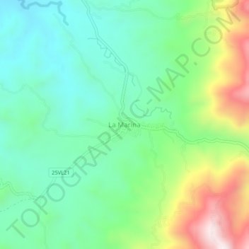
Navn: Topografisk kort La Marina, højde, relief.
Sted: La Marina, Centro, Valle del Cauca, Colombia (4.02592 -76.13356 4.06592 -76.09356)
Gjennomsnittlig høyde: 1 352 m
Minste høyde: 1 136 m
Maksimal høyde: 1 825 m
Gi en donasjon
Andre topografiske kart
Klikk på et kart for å se dets topografi, dets høyde og dets relieff.
Cali
Colombia > Valle del Cauca > Cali
Under Köppen's climate classification, Cali features a dry-summer tropical monsoon climate (Köppen climate classification: Am), bordering a tropical savanna climate (Köppen: As). The Western Mountain Range rises from an average of 2,000 m (6,562 ft) above sea level in the northern part of the city to…
Gjennomsnittlig høyde: 1 140 m
Gi en donasjon
Cali
Under Köppen's climate classification, Cali features a dry-summer tropical monsoon climate (Köppen climate classification: Am), bordering a tropical savanna climate (Köppen: As). The Western Mountain Range rises from an average of 2,000 m (6,562 ft) above sea level in the northern part of the city to…
Gjennomsnittlig høyde: 1 284 m
Gi en donasjon
Yumbo
Yumbo has a relatively dry but extremely foggy and sunless tropical savanna climate (Köppen Aw) not unlike the climate of Bogotá except substantially hotter due to the lower elevation.
Gjennomsnittlig høyde: 1 251 m
Cali
Under Köppen's climate classification, Cali features a dry-summer tropical monsoon climate (Köppen climate classification: Am), bordering a tropical savanna climate (Köppen: As). The Western Mountain Range rises from an average of 2,000 m (6,562 ft) above sea level in the northern part of the city to…
Gjennomsnittlig høyde: 1 572 m
Gi en donasjon
Cali
Under Köppen's climate classification, Cali features a dry-summer tropical savanna climate (Köppen climate classification: As), closely bordering a tropical monsoon climate (Köppen: Am). The Western Mountain Range rises from an average of 2,000 m (6,562 ft) above sea level in the northern part of the city…
Gjennomsnittlig høyde: 1 284 m
Cali
Under Köppen's climate classification, Cali features a dry-summer tropical savanna climate (Köppen climate classification: As). The Western Mountain Range rises from an average of 2,000 m (6,562 ft) above sea level in the northern part of the city to approximately 4,000 m (13,123 ft) to the south. Because of…
Gjennomsnittlig høyde: 1 284 m
Gi en donasjon
Cali
Under Köppen's climate classification, Cali features a dry-summer tropical savanna climate (Köppen climate classification: As), closely bordering a tropical monsoon climate (Köppen: Am). The Western Mountain Range rises from an average of 2,000 m (6,562 ft) above sea level in the northern part of the city…
Gjennomsnittlig høyde: 1 286 m
Gi en donasjon
Cali
Under Köppen's climate classification, Cali features a dry-summer tropical savanna climate (Köppen climate classification: As). The Western Mountain Range rises from an average of 2,000 m (6,562 ft) above sea level in the northern part of the city to approximately 4,000 m (13,123 ft) to the south. Because of…
Gjennomsnittlig høyde: 1 284 m
Cali
Colombia > Valle del Cauca > Cali
Under Köppen's climate classification, Cali features a dry-summer tropical savanna climate (Köppen climate classification: As). The Western Mountain Range rises from an average of 2,000 m (6,562 ft) above sea level in the northern part of the city to approximately 4,000 m (13,123 ft) to the south. Because of…
Gjennomsnittlig høyde: 1 142 m
Gi en donasjon
Cali
Colombia > Valle del Cauca > Cali
Under Köppen's climate classification, Cali features a dry-summer tropical savanna climate (Köppen climate classification: As). The Western Mountain Range rises from an average of 2,000 m (6,562 ft) above sea level in the northern part of the city to approximately 4,000 m (13,123 ft) to the south. Because of…
Gjennomsnittlig høyde: 1 140 m
Santa Helena
Colombia > Valle del Cauca > Perímetro Urbano Santiago de Cali
Gjennomsnittlig høyde: 960 m
Palmira
Palmira is located in southwestern Colombia, lying in the Cauca River valley. 3°31’48” north altitude and 76°81’13” longitude west of Greenwich. The city covers an area of 1,160 km2 (448 sq mi). The city lies at an elevation of 1,000 m (3,300 ft) above sea level.
Gjennomsnittlig høyde: 1 600 m
Gi en donasjon