
Gi en donasjon
Topografisk kart Vinings
Klikk på kartet for å vise høyde.
Gi en donasjon
Vinings
Vinings features a varied topography characterized by rolling hills and lush, wooded areas that provide a picturesque backdrop to the community. The area is nestled alongside the Chattahoochee River, which contributes to the gentle slopes and valleys that define the landscape. Elevations in Vinings typically range from around 800 to 1,000 feet above sea level, offering residents and visitors scenic views of the surrounding hills. The terrain is interspersed with green spaces and parks, enhancing its natural beauty and providing recreational opportunities amidst the suburban environment. Additionally, the proximity to the river and nearby Atlanta contributes to the area's vibrant ecosystem, making Vinings a desirable place to live and explore.
Gi en donasjon
Om dette kartet
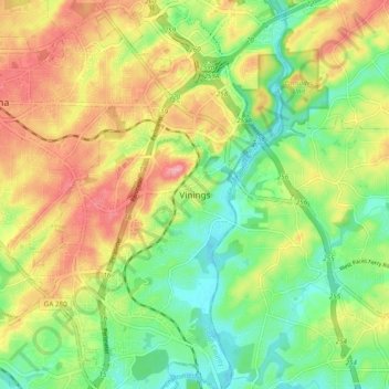
Navn: Topografisk kort Vinings, højde, relief.
Sted: Vinings, Cobb County, Georgia, 30339, United States (33.82483 -84.50437 33.90483 -84.42437)
Gjennomsnittlig høyde: 281 m
Minste høyde: 228 m
Maksimal høyde: 346 m
Gi en donasjon
Andre topografiske kart
Klikk på et kart for å se dets topografi, dets høyde og dets relieff.
Kennesaw
United States > Georgia > Cobb County
Kennesaw is located in northwestern Cobb County, bordered by the city of Acworth to the northwest. Kennesaw Mountain is located southeast of the city limits in the battlefield park. Its summit is the highest point in the Atlanta metro area, at an elevation of 1,808 feet (551 m) above sea level. The city was…
Gjennomsnittlig høyde: 317 m
Gi en donasjon
Gi en donasjon
Gi en donasjon
Gi en donasjon
Kennesaw
United States > Georgia > Cobb County
Kennesaw is located in northwestern Cobb County, bordered by the city of Acworth to the northwest. Kennesaw Mountain is located southeast of the city limits in the battlefield park. Its summit is the highest point in the Atlanta metro area, at an elevation of 1,808 feet (551 m) above sea level. The city was…
Gjennomsnittlig høyde: 317 m