
Gi en donasjon
Topografisk kart Cerro Nutibara
Klikk på kartet for å vise høyde.
Gi en donasjon
Om dette kartet
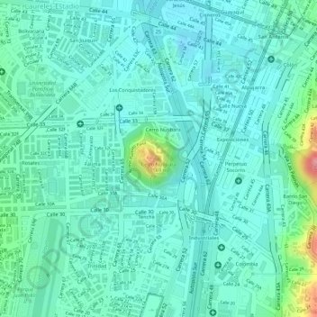
Navn: Topografisk kort Cerro Nutibara, højde, relief.
Gjennomsnittlig høyde: 1 486 m
Minste høyde: 1 460 m
Maksimal høyde: 1 581 m
Gi en donasjon
Andre topografiske kart
Klikk på et kart for å se dets topografi, dets høyde og dets relieff.
Comuna 14 - El Poblado
Colombia > Antioquia > Medellín
El Poblado consists of 1,432.58 hectares (3,540.0 acres), encompassing 39% of the Medellín municipality. It is located in the southeastern zone of the city towards the mountains of the Aburrá Valley. The Medellín River borders its western side, separating it from the Guayabal Commune and its elevation east…
Gjennomsnittlig høyde: 1 732 m
Gi en donasjon